
File:North america terrain 2003 map.jpg
| |
This is a file from the Wikimedia Commons. Information from its description page there is shown below.
Commons is a freely licensed media file repository. You can help. |
| |
This is a featured picture, which means that members of the community have identified it as one of the finest images on the English Wikipedia, adding significantly to its accompanying article. If you have a different image of similar quality, be sure to upload it using the proper free license tag, add it to a relevant article, and nominate it. |
| |
This image was selected as picture of the day on the English Wikipedia for June 19, 2005, and April 21, 2007. |
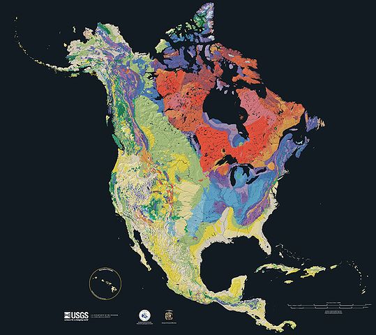
Relief map showing the varying age of bedrock underlying North America.
This cartographic tapestry is woven from a geologic map and a shaded relief image. This combination reveals the geologic history of North America through the interrelation of rock type, topography and time. Regional surface processes as well as continent-scale tectonic events are exposed in the three dimensions of space and the fourth dimension, geologic time.
From most recent to oldest, age is indicated by: yellow, green, blue, red.

The red U-shape of the Canadian Shield is clearly apparent. The base of ancient mountains and impact craters, this mineral-rich rock is nearly bare due to recent ice ages.

The Canadian Shield is an exposed part of the North American craton, a stable area which extends down the continent along the blue areas, and includes the sweep east of the Rocky Mountains back northward along the pale yellows of the Great Plains, light green across Wyoming and nearly to Alaska.
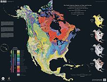
Rock types
Four maps show the North American distribution of four principal types of rock: sedimentary, volcanic, plutonic and metamorphic rock.
-

Plutonic rock
Source
The North America Tapestry of Time and Terrain (1:8,000,000 scale) is a product of the United States Geological Survey in the I-map series (I-2781). This map was prepared in collaboration with the Geological Survey of Canada and the Mexican Consejo Recursos de Minerales .
Home: http://pubs.usgs.gov/imap/i2781/
Image: http://pubs.usgs.gov/imap/i2781/i2781_c_low.pdf 144 dpi, encoded to 72 dpi JPEG, compressed slightly to fit within Wikipedia 2MB limit.
English Wikipedia, original upload 15 April 2005 by SEWilco
 |
This image is a work of a United States Geological Survey employee, taken or made as part of that person's official duties. As a work of the United States Government, the image is in the public domain. For more information, see the USGS copyright policy. See Wikipedia:Public domain and Wikipedia:Copyrights for more details. | |
 |
This is a candidate to be copied to Wikimedia Commons. Freely licensed or public domain media are more accessible to other Wikimedia projects if placed on Commons. Any user may perform this move—please see Moving images to the Commons for more information. Please thoroughly review the copyright status of this file and ensure that it is actually eligible for transfer to Commons. If you are concerned that this file could have problems with its attribution information and/or copyright status, then remove this notice and DO NOT transfer it to Commons. By transferring this file to Commons, you acknowledge you have read this message and are willing to accept any and all consequences for inappropriate transfers. Repeat violators will be blocked from editing. If you have checked the file and it is OK to move to Commons add "|human=username" to the template so other users can see it has been checked and can help you copy the file to Commons. If the file can't be moved to Commons consider nominating the file for deletion or changing the template to {{NotMovedToCommons|reason=Why it can't be copied to Commons}} If this image has been copied to Commons replace this tag with {{subst:ncd}} or {{subst:ncd|Image name on Commons.ext}} if a different filename is used on Commons. Copy to Commons: via CommonsHelper |
||
|
|||
|
Relief map showing the varying age of bedrock underlying North America.
This cartographic tapestry is woven from a geologic map and a shaded relief image. This combination reveals the geologic history of North America through the interrelation of rock type, topography and time. Regional surface processes as well as continent-scale tectonic events are exposed in the three dimensions of space and the fourth dimension, geologic time.
From most recent to oldest, age is indicated by: yellow, green, blue, red.

The red U-shape of the Canadian Shield is clearly apparent. The base of ancient mountains and impact craters, this mineral-rich rock is nearly bare due to recent ice ages.
The Canadian Shield is an exposed part of the North American craton, a stable area which extends down the continent along the blue areas, and includes the sweep east of the Rocky Mountains back northward along the pale yellows of the Great Plains, light green across Wyoming and nearly to Alaska.
Rock types
Four maps show the North American distribution of four principal types of rock: sedimentary, volcanic, plutonic and metamorphic rock.
-

Metamorphic rock
-
Plutonic rock
-

Sedimentary rock
-

Volcanic rock
Source
The North America Tapestry of Time and Terrain (1:8,000,000 scale) is a product of the United States Geological Survey in the I-map series (I-2781). This map was prepared in collaboration with the Geological Survey of Canada and the Mexican Consejo Recursos de Minerales .
Home: http://pubs.usgs.gov/imap/i2781/
Image: http://pubs.usgs.gov/imap/i2781/i2781_c_low.pdf 144 dpi, encoded to 72 dpi JPEG, compressed slightly to fit within Wikipedia 2MB limit.
English Wikipedia, original upload 15 April 2005 by SEWilco
 |
This image is in the public domain because it contains materials that originally came from the United States Geological Survey, an agency of the United States Department of the Interior. For more information, see the official USGS copyright policy. български | català | Deutsch | English | español | eesti | suomi | français | galego | italiano | 한국어 | македонски | മലയാളം | Nederlands | polski | português | русский | Türkçe | 中文(香港) | 中文(简体) | +/− |
|
File usage
Background information
This selection has made Wikipedia available to all children. SOS Children's Villages believes that a decent childhood is essential to a happy, healthy. Our community work brings families new opportunities through education, healthcare and all manner of support. Go to http://www.soschildrensvillages.org.uk/sponsor-a-child to sponsor a child.