Geography of Nigeria
Background Information
This selection is made for schools by a children's charity read more. Before you decide about sponsoring a child, why not learn about different sponsorship charities first?
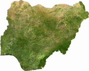
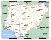
Nigeria is a country in West Africa. Nigeria shares land borders with the Republic of Benin in the west, Chad and Cameroon in the east, and Niger in the north. Its coast lies on the Gulf of Guinea in the south and it borders Lake Chad to the northeast. Noted geographical features in Nigeria include the Adamawa highlands,Mambilla plateau, Jos Plateau and Obudu Plateaus and the Niger River and Niger Delta. The country's geographic coordinates are 10°00′N 8°00′E
Area and boundaries
The total area of Nigeria is 923,768 km². 910,768 km² of that is land, while water takes up 13 000 km². Nigeria's total boundaries are 4 047 km in length. The countries it borders account for most of this. The border with Benin is 773 km, that with Cameroon is 1,690 km, Chad's is 87 km, and Niger's is 1,497 km. Nigeria's coastline is 853 km.
Nigeria makes the following maritime claims:
continental shelf: 200-m depth or to the depth of exploitation
exclusive economic zone: 200 nmi (370.4 km; 230.2 mi)
territorial sea: 12 nmi (22.2 km; 13.8 mi)
Climate
Nigeria has a varied climate. Four climate zones can be distinguished as one moves from the southern part of the country to the northern part of the country.
The southern part of the country has an equatorial monsoonal climate influenced by the south west monsoonal winds (maritime tropical) MT coming from the South Atlantic ocean. Temperature ranges are small and constant throughout the year, Warri for example has its hottest month with 28 degrees centigrade and its coolest month with 26 degrees centigrade with the temperature range of not more than 2 degrees. Precipitation is heavy, between 1824mm to 4000mm along the coast. Rain falls throughout the year with a short break in August and a longer break from December to January. The central region of Nigeria has a tropical humid climate, this region has a well marked rainy season which lasts from March to October and a pronounced dry season which lasts from November to March. Temperatures are hot during the dry season but the onset of the rains lowers the temperatures. The northern part of the country exhibits the Tropical dry climate where rainfall is recorded for only three to four months (June-September). The rest of the year is dry and hot with temperature going up to 40 degrees centigrade. The montane or highland climate can be found on different highland regions in the country (Nigeria). Most highlands in Nigeria are over 1000 meters high which forces temperatures to remain cold on them throughout the year.
The main influence on weather in Nigeria are the trade winds, the south west trade winds from the southern part of the country originating from the Atlantic Ocean and is responsible for Nigeria's rainy season, and the north east trade winds from the northern part of the country originating from the Sahara Desert is responsible for the Harmattan, a dry dusty wind that blows across the country from November to March.
Seasons
Nigeria's climate is marked by two seasons. The two seasons in Nigeria are influenced by two different air masses, the tropical maritime (MT) airmass from the South Atlantic Ocean and the tropical continental (CT) airmass from the Sahara desert. These two major winds are called the trade winds.
Trade winds
Tropical maritime airmass
The tropical maritime (MT) airmass invades the country from February in the southern part to June in the far north. Its invasion follows the retreat of the tropical continental (CT) airmass northwards. The reason for the retreat of the tropical continental (CT) airmass is caused by the sun's northward migration to the Tropic of Cancer from February to June. When the sun is overhead north of the equator, the landmass of West Africa is heated intensely at this time of the year and insolation is increased with temperatures hovering above 35 degrees centigrade for most part of the region(west Africa)because of the sun's overhead position. Temperatures can go as high as 40 degrees centigrade during the afternoons. This intense heating of west Africa and Nigeria in particular causes the land to warm, the warming of the land weakens the strength of the Tropical continental (CT) airmass. The heat sets the CT airmass in the Sahara Desert to rise up in convection currents thereby creating a region of low pressure area in the sahara desert and northern Nigeria. This empty air vacuum created by the weakening of the CT) airmass acts as a strong attraction to the Tropical Maritime (MT) airmass from the South Atlantic Ocean to move in to replace the empty low pressure area created as a result of the temporary disappearance of the CT airmass. The Tropical maritime airmass is a warm humid air that is unstable (always rising) and so convectional currents are easily set up in the warm moist air following the sun's heating of the land which in turn warms the air above the land making the air to become lighter and rise vertically in the form of convection currents, thereby allowing for the high frequency of convectional rainfall within this airmass.
The MT airmass due to its instability in characteristics is easily forced to rise when it encounters highlands, orographic clouds are formed and heavy rains follow. Places that experience this type of rainfall in Nigeria are the Jos Plateau, Mambila plateau, Obudu plateau, Shebshi mountains in Adamawa State, Western highlands in western Nigeria and central highlands in southern Kaduna State.
Apart from the orographic rainfall, rain in most parts of Nigeria is convectional in making. Mornings are bright and sunny, the sun's heating of the land in the mornings and early afternoons causes convectional currents to set in motion. The rising of the warm air triggers off the formation of cumulonimbus clouds (hot tower cloud) or the thunderstorm cloud in the afternoons and evenings, and torrential downpours occur. As a result of high instability (always raising due to temperature differences within the airmass) in the tropical maritime (MT) airmass and high humidity of over 80%, rain can be a daily occurrence in the rainy season which is well over Nigeria from June to September. It has also been established that a large percentage of convectional rainfall in Nigeria and west Africa (generally from April to October) are caused by the interactions of the tropical maritime (MT) with another airmass called the Easterlies (Maritime Equatorial (ME)). This airmass is dry because it has exhausted its moisture content on crossing the equator from East Africa. It dives into the MT airmass from the tropopause thereby blocking MT northward movement from the south. The MT is easily set to rise as a result of this blockage, cumulonimbus clouds in form of squall lines are formed and the rain from this interactions is violent and can be destructive. It is more common at the beginning and ending of rainfall in Nigeria (April to October).
Tropical continental airmass
The sun's migration from the north of the equator to the Tropic of Capricorn in the south of the equator in September provides less insolation over West and North Africa at this time (September-December). The Sahara Desert is now cold, a region of high pressure is set up all over North Africa. The tropical continental airmass (CT) is formed,the tropical maritime airmass (MT) begins to retreat to the south as it follows the sun's southward migration to the Tropic of Capricorn. The CT airmass now invades Nigeria from the north-east, it is responsible for Nigeria's dry season. The CT airmass picks up dust particles from the Sahara Desert and travels with it thereby making the people in sub-Saharan Africa to give it the name Harmattan, because the dust it picks from the desert creates a haze within the atmosphere.
Effects of the tropical continental airmass
There is no rain because the airmass originates from the Sahara desert with little humidity as a result of an absence of a large body of water in the desert and the airmass is stable (not rising, cold air is dense and heavy and doesn't rise but sink). Life can be unbearable because of the low visibility and the dust haze makes most parts of the country look like semi-desert. But it also brings relief to farmers because of the low humidity in the air that quickens the drying of their crops.
Temperature
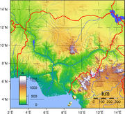
Nigeria is generally a hot country. Temperature ranges vary according to the seasons in a year. Unlike temperate lands that experience four seasons which are determined by changes in temperature, Nigeria experiences only two seasons: the rainy season and the dry season. Rainfall is the determinant factor of seasons in Nigeria, as with most tropical lands. Nigeria's average temperature is 27 degrees centigrade. But not all parts of Nigeria are hot, there are mountainous districts in Nigeria that are semi- temperate in weather, they include the cold and scenic Jos Plateau 1200 meters above sea level with temperatures ranging from 18 degrees to 25 degrees centigrade, another cold plateau in Nigeria is the Mambila plateau located in Taraba State. Mambilla plateau is the highest plateau in Nigeria with a height averaging 1800 meters above sea level. The temperature on this plateau is temperate throughout the year (it rarely goes above 25 degrees centigrade during the day time making it the coldest plateau in Nigeria) and the largest town on the plateau is Gembu town in Sardauna L G A on the plateau. The Obudu mountain resort 1500 meters above sea level is another well known hotspot for tourists seeking to escape the enervating and mental tasking high temperatures and humidity of tropical climate zones of Nigeria. Obudu plateau has similar climatic conditions to temperate land autumn season.
The Biu Plateau 800 meters above sea level in southern Borno state experiences similar cold weather conditions to Jos town on the Jos Plateau.
Topography
Nigeria's most expansive topographical region is that of the valleys of the Niger and Benue River valleys (which merge into each other and form a "y" shape). Plains rise to the north of the valleys. To the southwest of the Niger there is "rugged" highland, and to the southeast of the Benue hills and mountains are found all the way to the border with Cameroon. Coastal plains are found in both the southwest and the southeast.
Niger Delta
The Niger Delta is located in the southern part of Nigeria. It is one of the world's largest arcuate (fan-shaped river deltas.
The riverine area of the Niger Delta is a coastal belt of swamps bordering the Atlantic ocean.The swamps are vegetated tidal flats formed by a reticulate pattern of interconnected meandering creeks and distributaries of the River Niger.
Vegetation of the Niger Delta
The vegetation of the Niger Delta consist mainly of forest swamps.The forest are of two types,nearest the sea is a belt of saline/brackish Mangrove swamp separated from the sea by sand beach ridges within the mangrove swamp.Numerous sandy islands occur with fresh water vegetation. Fresh water swamps gradually supersede the mangrove on the landward side. About 70% of Nigeria's crude oil and gas production is from the area.
Human population in the Niger Delta
The riverine area is home to a large population of people living mainly in small villages scattered along the banks of rivers and creeks.
Rainfall in Niger Delta
Rainfall in the coastal belt of the Niger Delta is heavy due to the closeness of the Delta region to the equator. Annual rainfall totals vary from 2400 to over 4000 millimeters.
Niger Delta cities and their annually rainfall totals in millimeters:
- Warri — 2,730mm
- Forcados (coastal town in the Delta) — 4,870mm
- Port Harcourt — 2,400mm
- Calabar (coastal city) — 3,070mm (rainiest city with over one million people in Nigeria)
- Bonny (south of Port Harcourt) — 4,200mm
Vegetation
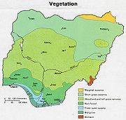
Nigeria is covered by three types of vegetation: forests (where there is significant tree cover), savannahs (insignificant tree cover, with grasses and flowers located between trees), and montane land. (The latter is the least common, and is mainly found in the mountains near the Cameroonian border.) Both the forest zone and the savannah zone are divided into three parts.
Some of the forest zone's most southerly portion, especially around the Niger River and Cross River deltas, is mangrove swamp (see Central African mangroves). North of this is fresh water swamp, containing different vegetation from the salt water mangrove swamps, and north of that is rain forest.
The savannah zone's three categories are divided into mm' Guinean forest-savanna mosaic, made up of plains of tall grass which are interrupted by trees, the most common across the country; Sudan savannah, similar but with shorter grasses and shorter trees; and Sahel savannah patches of grass and sand, found in the northeast.


