River
Background to the schools Wikipedia
This selection is made for schools by a children's charity read more. Click here for more information on SOS Children.

A river is a natural stream of water, usually freshwater, flowing toward an ocean, a lake, or another stream. In some cases a river flows into the ground or dries up completely before reaching another body of water. Usually larger streams are called rivers while smaller streams are called creeks, brooks, rivulets, rills, and many other terms, but there is no general rule that defines what can be called a river. Sometimes a river is said to be larger than a creek, but this is not always the case.
A river is a component of the water cycle. The water within a river is generally collected from precipitation through surface runoff, groundwater recharge (as seen at baseflow conditions / during periods of lack of precipitation) and release of stored water in natural reservoirs, such as a glacier.
Origins
A river may have its source in a spring, lake, from damp, boggy landscapes where the soil is waterlogged, from glacial melt, or from surface runoff of precipitation. Almost all rivers are joined by other rivers and streams termed tributaries, the highest of which are known as headwaters. Water may also originate from groundwater sources. Throughout the course of the river, the total volume transported downstream will often be a combination of the free water flow together with a substantial contribution flowing through sub-surface rocks and gravels that underlie the river and its floodplain. For many rivers in large valleys, this unseen component of flow may greatly exceed the visible flow.
From their source, rivers flow downhill, typically terminating in a sea or in a lake, through a confluence. In arid areas rivers sometimes end by losing water to evaporation. River water may also infiltrate into the soil or pervious rock, where it becomes groundwater. Excessive abstraction of water for use in industry, irrigation, etc., can also cause a river to dry before reaching its natural terminus.
The mouth, or lower end, of a river is known as its base level. The area drained by a river and its canals is called catchment, catchment basin, drainage basin or watershed. The term "watershed" is also used to mean a boundary between catchments, which is also called a water divide, or in some, continental divide.
Topography
The water in a river is usually confined to a channel, made up of a stream bed between banks. In larger rivers there is also a wider floodplain shaped by flood-waters over-topping the channel. Flood plains may be very wide in relation to the size of the river channel. This distinction between river channel and floodplain can be blurred especially in urban areas where the floodplain of a river channel can become greatly developed by housing and industry.
The term upriver, is referred to as the beginning or source of the river flow regardless of the direction of flow. Therefore, the term down river, is referring to the direction of flow that the river continues in.
The river channel typically contains a single stream of water, but some rivers flow as several interconnecting streams of water, producing a braided river. Extensive braided rivers are found in only a few regions worldwide, such as the South Island of New Zealand. They also occur on peneplains and some of the larger river deltas. Anastamosing rivers are similar to braided rivers and are also quite rare. They have multiple sinuous channels carrying large volumes of sediment.
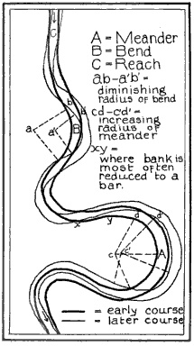
A river flowing in its channel is a source of energy which acts on the river channel to change its shape and form. According to Brahm's law (sometimes called Airy's law), the mass of objects that may be flown away by a river is proportional to the sixth power of the river flow speed. Thus, when the speed of flow increases two times, it can transport 64 times larger (i.e. more massive) objects. In mountainous torrential zones this can be seen as erosion channels through hard rocks and the creation of sands and gravels from the destruction of larger rocks. In U shaped glaciated valleys, the subsequent river valley can often easily be identified by the V shaped channel that it has carved. In the middle reaches where the river may flow over flatter land, meanders may form through erosion of the river banks and deposition on the inside of bends. Sometimes the river will cut off a loop, shortening the channel and forming an oxbow lake or billabong. Rivers that carry large amounts of sediment may develop conspicuous deltas at their mouths, if conditions permit. Rivers whose mouths are in saline tidal waters may form estuaries.
Classification
Although the following classes are a useful way to visualize rivers, there are many other factors at work. Gradient is controlled largely by tectonics, but discharge is controlled largely by climate, and sediment load is controlled by various factors including climate, geology in the headwaters, and the stream gradient.
- Youthful river
- a river with a steep gradient that has very few tributaries and flows quickly. Its channels erode deeper rather than wider. (Examples: Brazos River, Trinity River, Ebro River)
- Mature river
- a river with a gradient that is less steep than those of youthful rivers and flows more slowly than youthful rivers. A mature river is fed by many tributaries and has more discharge than a youthful river. Its channels erode wider rather than deeper. (Examples: Mississippi River, St. Lawrence River, Danube River, Ohio River, River Thames)
- Old river
- a river with a low gradient and low erosive energy. Old rivers are characterized by flood plains. (Examples: Huang He River, Ganges River, Tigris, Euphrates River, Indus River, Nile River)
- Rejuvenated river
- a river with a gradient that is raised by tectonic uplift.
The straight-line distance from the beginning to the end of most rivers is about one third their actual length.
The way which a river's characteristics vary between the upper course and lower course of a river is summarized by the Bradshaw model.
Most rivers flow on the surface; however subterranean rivers flow underground in caves or caverns. Such rivers can be found in remote regions like Antarctica with limestone geologic formations.
An intermittent river (or ephemeral river) only flows occasionally and can be dry for several years at a time. These rivers are found in regions with limited or highly variable rainfall, or can occur due to geologic conditions such as having a highly permeable river bed.
Uses
Rivers have been used as a source of water, for food, for transport, as a defensive barrier, as a source of power to drive machinery, and as a means of disposing of waste.
For thousands of years rivers have been used for navigation (The earliest evidence of navigation is found in the Indus Valley Civilization, which existed in northwestern India around 3300 BC). Riverine navigation provides the cheapest means of transport and is still used extensively on major rivers of the world like the Ganges, the Nile, the Mississippi, and the Indus.
In some heavily-forested regions like Scandinavia and Canada, lumberjacks use the river to float felled trees downstream to lumber camps for further processing, saving much effort and cost by transporting the huge heavy logs by natural means.
Rivers have been a source of food since pre-history. Apart from being a rich source of fish, rivers indirectly aid cultivation by supplying water for the crops. Rivers sustain their own food chain. They are a major source of fresh water, hence, it is no surprise to find most of the major cities of the world situated on the banks of rivers. Rivers help to determine the urban form of cities and neighbourhoods and their corridors often present opportunities for urban renewal through the development of foreshoreways such as Riverwalks. Rivers also provide an easy means of disposing of waste.
The rocks and gravel generated and moved by rivers are used in construction. The beauty of rivers and their surroundings contributes to tourist income.
In upland rivers, rapids with whitewater or even waterfalls occur. Rapids are often used for recreational purposes, such as whitewater kayaking. Fast flowing rivers and waterfalls are harnessed as sources of energy, via watermills and hydroelectric plants.
Rivers have been important in determining political boundaries and defending countries. For example, the Danube was a longstanding border of the Roman Empire, and today it forms most of the border between Bulgaria and Romania. The Mississippi in North America and the Rhine in Europe are major east-west boundaries in those continents. The Orange and Limpopo Rivers in southern Africa form the boundaries between provinces and countries along their routes.
Ancient Greek historian Megasthenes mentions about River Ganga several times in his work Indika: "India, again, possesses many rivers both large and navigable, which, having their sources in the mountains which stretch along the northern frontier, traverse the level country, and not a few of these, after uniting with each other, fall into the river called the Ganges. Now this river, which at its source is 30 stadia broad, flows from north to south, and empties its waters into the ocean forming the eastern boundary of the Gangaridai, a nation which possesses a vast force of the largest-sized elephants." (Diodorus II.37.)
Biology
The flora and fauna of rivers use the aquatic habitats available, from torrential waterfalls through to lowland mires. Although many organisms are restricted to the fresh water in rivers, some, such as Salmon and Hilsa, have adapted to be able to survive both in rivers and in the sea.
Flooding
Flooding is a natural part of a river's cycle. The majority of the erosion of river channels and the erosion and deposition on the associated floodplains occur during flood stage. Human activity, however, has upset the natural way flooding occurs by walling off rivers, straightening their courses and by draining of natural wetlands.
Flow
Direction
Some people think that most rivers flow from north to south. Rivers in fact flow downhill regardless of direction, often in a complex meandering path involving all directions of the compass.
Few major rivers in the continental U.S. flow north since most of the country is located in the watershed of the Pacific or Atlantic oceans or the Gulf of Mexico, with very few rivers flowing northward toward the Arctic Ocean, Great Lakes, or Hudson Bay. However, thousands of north-flowing rivers exist elsewhere, including such major watercourses as the Nile, Mackenzie, Rhine, Yenisei, Nelson, and Lena. Four of the ten longest river systems of the world flow mainly north.
Rate
Volumetric flow rate, also called volume flow rate and rate of water flow, is the volume of water which passes through a given volume per unit time, measured in cubic meters per second (1 m³/s = 35.51 ft³/s) or cubic feet per second, sometimes gallons per second.
Management
Rivers are often managed or controlled to make them more useful, or less disruptive, to human activity.
- Dams or weirs may be built to control the flow, store water, or extract energy.
- Levees, known as dikes in Europe, may be built to prevent river water from flowing on floodplains or floodways.
- Canals connect rivers to one another for water transfer or navigation.
- River courses may be modified to improve navigation, or straightened to increase the flow rate.
River management is a continuous activity as rivers tend to 'undo' the modifications made by people. Dredged channels silt up, sluice mechanisms deteriorate with age, levees and dams may suffer seepage or catastrophic failure. The benefits sought through managing rivers may often be offset by the social and economic costs of mitigating the bad effects of such management. As an example, in parts of the developed world, rivers have been confined within channels to free up flat flood-plain land for development. Floods can inundate such development at high financial cost and often with loss of life.
Rating systems
- International Scale of River Difficulty – The scale is used to rate the challenges of navigation—particularly those with rapids. Class I is the easiest and Class VI is the hardest.
- Strahler Stream Order – The Strahler Stream Order ranks rivers based on the connectivity and hierarchy of contributing tributaries. Headwaters are first order while the Amazon River is twelfth order. Approximately 80% of the rivers and streams in the world are of the first and second order.
-
Río Peralonso - El Zulia ( Norte de Santander), Colombia
-
Zambezi and Victoria Falls (Zambia/Zimbabwe, Africa)
-
Chosen5.JPG
Heathcote National Park


