
File:Shattering isochamend.png
| |
This is a file from the Wikimedia Commons. Information from its description page there is shown below.
Commons is a freely licensed media file repository. You can help. |
Summary
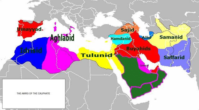
| Description | Isochronic map of Caliphate fragmentation |
| Date | |
| Source | self-made derived from  http://www.maproom.org/00/46/present.php?m=0082 Plate 82 from Hand-Atlas für die Geschichte des Mittelalters und die neueren Zeit by Spruner and Menke Index no. 0046:0082 The lands of Islam to the time of the Buyids, 945-1055. Southern Arabia. (Western continuation of the main map.) The Ghaznavid Empire about 1002/3. The Eastern Roman Empire about 1002/3. — Die Länder des Islâm zur Zeit der Bûjiden 945-1055. Südliches Arabien. Reich der Ghazneviden um 1002/3. Oströmisches Reich 1021 bis 1055 http://www.maproom.org/00/08/present.php?m=0077 Plate 77 from Professor G. Droysens Allgemeiner Historischer Handatlas by R. Andree Index no. 0008:0077 The Caliphate, to 945 — Reich der Kalifen bis 945 |
| Author | Busterof666 |
Licensing
 |
I, the copyright holder of this work, release this work into the public domain. This applies worldwide. In some countries this may not be legally possible; if so: I grant anyone the right to use this work for any purpose, without any conditions, unless such conditions are required by law.
|
| Annotations | This image is annotated: View the annotations at Commons |
File usage
Learn more about Schools Wikipedia
Through Schools Wikipedia, SOS Children's Villages has brought learning to children around the world. SOS Children is a global charity founded in 1949 to give children who have lost everything the childhood they deserve. There are many ways to help with SOS Children.