
File:Detail of map of Plymouth, Devon circa 1600.PNG
Summary
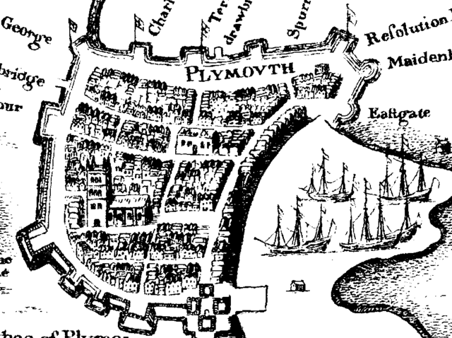
Detail of map of Plymouth, Devon circa 1600. I am fairly certain this map is out of copyright. Copies are available from Plymouth Central Library, Devon UK.
Note on the map St Andrew's Church to the lower centre left and Charles church to the upper centre. Charles church clearly does not have a roof or spire at this point.
Licensing
 |
This file is in the public domain because its copyright has expired in the United States and those countries with a copyright term of no more than the life of the author plus 100 years. |
The building suggested cannot be Charles Church which was not authorised until 1640. Besides, it is wrongly located. It is more likely to be the Market.
 |
This is a candidate to be copied to Wikimedia Commons. Freely licensed or public domain media are more accessible to other Wikimedia projects if placed on Commons. Any user may perform this move—please see Moving images to the Commons for more information. Please thoroughly review the copyright status of this file and ensure that it is actually eligible for transfer to Commons. If you are concerned that this file could have problems with its attribution information and/or copyright status, then remove this notice and DO NOT transfer it to Commons. By transferring this file to Commons, you acknowledge you have read this message and are willing to accept any and all consequences for inappropriate transfers. Repeat violators will be blocked from editing. If you have checked the file and it is OK to move to Commons add "|human=username" to the template so other users can see it has been checked and can help you copy the file to Commons. If the file can't be moved to Commons consider nominating the file for deletion or changing the template to {{NotMovedToCommons|reason=Why it can't be copied to Commons}} If this image has been copied to Commons replace this tag with {{subst:ncd}} or {{subst:ncd|Image name on Commons.ext}} if a different filename is used on Commons. Copy to Commons: via CommonsHelper |
||
|
|||
File usage
More information
Learning is fun and easy with Schools Wikipedia. SOS Childrens Villages is a global charity founded in 1949 to give children who have lost everything the childhood they deserve. Have you thought about sponsoring a child?