
File:Mississippi Territory dark.gif
Mississippi_Territory_dark.gif (480 × 431 pixels, file size: 16 KB, MIME type: image/gif)
| |
This is a file from the Wikimedia Commons. Information from its description page there is shown below.
Commons is a freely licensed media file repository. You can help. |
Summary
| Artist | self |
| Title |
English: Mississippi Territory and Alabama Territory
|
| Date | 2007 |
| Medium | MS-Paint, GIF file (16-colour palette, with dark hues) |
| Dimensions | 480px x 431px |
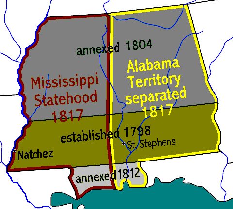
| Notes | Stylized map of the Mississippi Territory, showing changes from establishment in 1798, with area annexed in 1804 after the Louisiana Purchase, plus the area annexed after the War of 1812, and the 1817 division for Mississippi statehood creating the Alabama Territory (statehood in 1819). |
| Source/Photographer | ( Wikimedia Commons): Image:Mississippiterritory.PNG (file converted from PNG to GIF format, 5x times more compact, and modified to darken hues and widen lettering). |
Licensing
 |
I, the copyright holder of this work, release this work into the public domain. This applies worldwide. In some countries this may not be legally possible; if so: I grant anyone the right to use this work for any purpose, without any conditions, unless such conditions are required by law.
|
 |
This map image could be recreated using vector graphics as an SVG file. This has several advantages; see Commons:Media for cleanup for more information. If an SVG form of this image is already available, please upload it. After uploading an SVG, replace this template with {{ vector version available|new image name.svg}}. |
File usage
The following pages on Schools Wikipedia link to this image (list may be incomplete):
Schools Wikipedia facts
SOS Children chose the best bits of Wikipedia to help you learn. SOS Children's Villages cares for children who have lost their parents. Our Children's Villages give these children a new home and a new family, while a high-quality education and the best of medical care ensures they will grow up with all they need to succeed in adult life. There are many ways to help with SOS Childrens Villages.