|
This is a file from the Wikimedia Commons. Information from its description page there is shown below.
Commons is a freely licensed media file repository. You can help.
|
Summary
| Description |
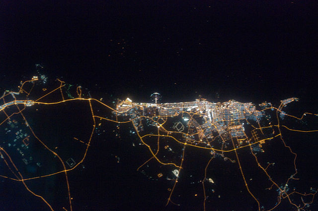
English: Orange sodium vapour lights trace the major highways and street grid in and around the metropolitan area, while grey-white mercury vapour lamps fill in the commercial and residential areas. The lighted islands and peninsula of Palm Jumeirah are clearly visible along the coastline. A spiral pattern of lights on the south-eastern fringe of the urban area is a camel racetrack. Night-time images like these are useful to climate modellers, urban planners, and geographers as they allow for simple definition of urban (densely lit) and rural (sparely lit) areas.
 ISS Crew Earth Observations: ISS020-E-39932 ISS Crew Earth Observations: ISS020-E-39932
| Identification |
| Mission |
ISS020 ( Expedition 20) |
| Roll |
E |
| Frame |
39932 |
| Country or Geographic Name |
UNITED ARAB EMIRATES |
| Features |
CITY OF DUBAI AT NIGHT, PALM ISLAND RESORT, PERSIAN GULF |
| Centre Point Latitude |
25.1° N |
| Centre Point Longitude |
55.1° E |
| Camera |
| Camera Tilt |
3° |
| Camera Focal Length |
80 mm |
| Camera |
Nikon D3 |
| Film |
4256 x 2832 pixel CMOS sensor, 36.0mm x 23.9mm, total pixels: 12.87 million, Nikon FX format. |
| Quality |
| Percentage of Cloud Cover |
0-10% |
| Nadir What is Nadir? |
| Date |
2009-09-11 |
| Time |
22:14:27 |
| Nadir Point Latitude |
25.2° N |
| Nadir Point Longitude |
55.2° E |
| Nadir to Photo Centre Direction |
Southwest |
| Sun Azimuth |
49° |
| Spacecraft Altitude |
185 nautical miles (343 km) |
| Sun Elevation Angle |
-49° |
| Orbit Number |
1961 |
| Original image caption |
| The city of Dubai is the largest metropolitan area in the emirate of Dubai, one of the member states of the United Arab Emirates. Dubai is located along the southern Persian Gulf on the Arabian Peninsula, and its signature city is known for high profile architectural and development projects. Among the most notable is the Palm Jumeirah, a man-made peninsula and surrounding islands built from over 50 million cubic meters of sand. Three other island projects, two similar to Palm Jumeirah and another crafted to look like a map of the world, are also underway along the Dubai coastline. This nighttime astronaut photograph of the city of Dubai was taken at approximately 2 a.m. local time on September 11, 2009. Orange sodium vapor lights trace the major highways and street grid in and around the metropolitan area, while grey-white mercury vapor lamps fill in the commercial and residential areas. The lighted islands and peninsula of Palm Jumeirah are clearly visible along the coastline. A spiral pattern of lights on the southeastern fringe of the urban area is a camel racetrack. Nighttime images like these are useful to climate modelers, urban planners, and geographers as they allow for simple definition of urban (densely lit) and rural (sparely lit) areas.
|
|
| Date |
28 September 2009 |
| Source |
NASA Earth Observatory |
| Author |
This image was taken by the NASA Expedition 20 crew. |
|
Camera location
|
25° 6′ 0.00″ N, 55° 6′ 0.00″ E
|
This and other images at their locations on: Google Maps - Google Earth - OpenStreetMap |
( Info)25.1;55.1 |
 |
This image or video was catalogued by Johnson Space Centre of the United States National Aeronautics and Space Administration (NASA) under Photo ID: ISS020-E-39932.
This tag does not indicate the copyright status of the attached work. A normal copyright tag is still required. See Commons:Licensing for more information.
|
Image provided by the ISS Crew Earth Observations experiment and Image Science & Analysis Laboratory, Johnson Space Centre. Instrument: ISS - Digital Camera.
Licensing
| Public domainPublic domainfalsefalse |
 |
This file is in the public domain because it was solely created by NASA. NASA copyright policy states that "NASA material is not protected by copyright unless noted". (See Template:PD-USGov, NASA copyright policy page or JPL Image Use Policy.) |
|
|
|
Warnings:
- Use of NASA logos, insignia and emblems are restricted per US law 14 CFR 1221.
- The NASA website hosts a large number of images from the Soviet/ Russian space agency, and other non-American space agencies. These are not necessarily in the public domain.
- Materials based on Hubble Space Telescope data may be copyrighted if they are not explicitly produced by the STScI. See also {{ PD-Hubble}} and {{ Cc-Hubble}}.
- The SOHO (ESA & NASA) joint project implies that all materials created by its probe are copyrighted and require permission for commercial non-educational use.
- Images featured on the Astronomy Picture of the Day (APOD) web site may be copyrighted.
|
| Annotations |
This image is annotated: View the annotations at Commons |
|
|
380
299
99
81
1440
960
Palm Jumeirah|Taken with Nikon D3
File usage
The following pages on Schools Wikipedia link to this image (list may be incomplete):
This file contains additional information, probably added from the digital camera or scanner used to create or digitize it. If the file has been modified from its original state, some details may not fully reflect the modified file.
Schools Wikipedia has made the best of Wikipedia available to students. Thanks to SOS Children, 62,000 children are enjoying a happy childhood, with a healthy, prosperous future ahead of them. You can help by sponsoring a child.
