 |
This is a file from the Wikimedia Commons. Information from its description page there is shown below.
Commons is a freely licensed media file repository. You can help.
|
 |
This image was previously a featured picture, but community consensus determined that it no longer meets our featured-picture criteria. If you have a high-quality image that you believe meets the criteria, be sure to upload it, using the proper free-license tag, then add it to a relevant article and nominate it. |
 |
This image was selected as picture of the day on the English Wikipedia for August 15, 2006. |
 |
This media file has been protected from editing to prevent vandalism.
Please discuss changes on the talk page or request unprotection. |
|
|
|

|
  This is a featured picture on the English language Wikipedia ( Featured pictures) and is considered one of the finest images. This is a featured picture on the English language Wikipedia ( Featured pictures) and is considered one of the finest images.
If you think this file should be featured on Wikimedia Commons as well, feel free to nominate it.
If you have an image of similar quality that can be published under a suitable copyright license, be sure to upload it, tag it, and nominate it.
|
|
|
 |
Please note: This image is used in at least one case as a base map for a locator image; if you change or replace it in a way that moves its geographic features, images superimposed on it at specific locations will no longer be accurate. Please be careful. Thank you. |
Summary
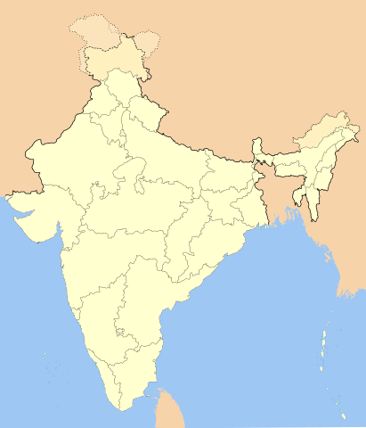
Blank locator map of India
SVG Map drawn by me, Nichalp using Inkscape.
Boundaries as per known in 2006.
Legend
| Colour |
Hex |
Transp |
Sample |
Key |
| Light green |
#ffffd0 |
100% |
|
Territory administered by India (undisputed) |
| Yellowish-orange |
#fff0bf |
20% |
|
Disputed area 1: Administered by India. Claimed by China/Pakistan |
| Orangish-Yellow |
#fbe3bb |
50% |
|
Disputed area 2: Administered by China/Pakistan. Claimed by India |
| Orange |
#f7d3aa |
50% |
|
Neighbouring countries |

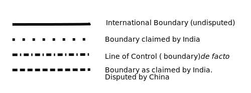
Boundary styles
Sources
Licensing
I, the copyright holder of this work, hereby publish it under the following licenses:
 |
Permission is granted to copy, distribute and/or modify this document under the terms of the GNU Free Documentation License, Version 1.2 or any later version published by the Free Software Foundation; with no Invariant Sections, no Front-Cover Texts, and no Back-Cover Texts. A copy of the license is included in the section entitled GNU Free Documentation License. http://www.gnu.org/copyleft/fdl.htmlGFDLGNU Free Documentation Licensetruetrue
|
You may select the license of your choice.
|
File usage
The following pages on Schools Wikipedia link to this image (list may be incomplete):
This file contains additional information, probably added from the digital camera or scanner used to create or digitize it. If the file has been modified from its original state, some details may not fully reflect the modified file.
Through Schools Wikipedia, SOS Children has brought learning to children around the world. SOS Children's Villages helps more than 2 million people across 133 countries around the world. Help another child by taking out a sponsorship


