File:InetCirca85.jpg

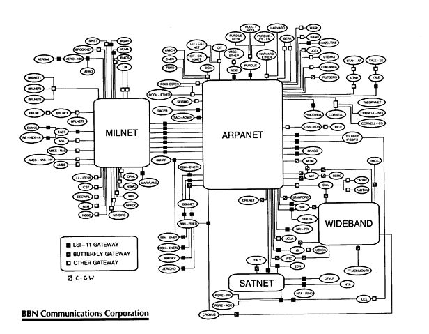
Contemporary map of the entire Internet, circa late-1985/early-1986 (from a presentation given at the second IETF meeting, in April, 1986). The little squares are routers, the small ovals are sites/networks (some sites included more than one physical network), and the large shapes are long-haul backbones. No individual hosts are shown.
Produced by Bob Hinden of Bolt, Beranek and Newman, under US government contract (and so PD). See the image's talk page for email from Bob with more details about its creation.
 |
This image is a work of a U.S. Military or Department of Defense employee, taken or made as part of that person's official duties. As a work of the U.S. federal government, the image is in the public domain. See DoD guidelines for imaging ethics concerning the use of its photographic and video images. |  |
 |
This is a candidate to be copied to Wikimedia Commons. Freely licensed or public domain media are more accessible to other Wikimedia projects if placed on Commons. Any user may perform this move—please see Moving images to the Commons for more information. Please thoroughly review the copyright status of this file and ensure that it is actually eligible for transfer to Commons. If you are concerned that this file could have problems with its attribution information and/or copyright status, then remove this notice and DO NOT transfer it to Commons. By transferring this file to Commons, you acknowledge you have read this message and are willing to accept any and all consequences for inappropriate transfers. Repeat violators will be blocked from editing. If you have checked the file and it is OK to move to Commons add "|human=username" to the template so other users can see it has been checked and can help you copy the file to Commons. If the file has already been moved to Commons, then consider nominating the file for deletion or changing the template to {{Already moved to Commons}} If the file can't be moved to Commons because it doesn't fit Common's scope, then use {{Do not move to Commons|reason=Why it can't be moved to Commons}} If you think that a local copy of this file should be kept, then use {{Keep local}}. Consider using {{Keep local|reason=Why the English Wikipedia needs a local copy}} Copy to Commons: via CommonsHelper |
||
|
|||
File usage
Metadata
I want to learn more...
Wikipedia for Schools is one of SOS Childrens Villages' many educational projects. SOS Childrens Villages believes education is an important part of a child's life. That's why we ensure they receive nursery care as well as high-quality primary and secondary education. When they leave school, we support the children in our care as they progress to vocational training or higher education. We have helped children in Africa for many years - you can help too...
