
File:Scg02.png
Size of this preview: 305 × 480 pixels.
| |
This is a file from the Wikimedia Commons. Information from its description page there is shown below.
Commons is a freely licensed media file repository. You can help. |
Summary
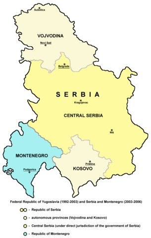
- English: Federal Republic of Yugoslavia (1992-2003) and Serbia and Montenegro (2003-2006).
- Serbian: Savezna Republika Jugoslavija (1992-2003) i Srbija i Crna Gora (2003-2006).
References
- Slobodan Radovanović, Geografski atlas, Magic Map, Smederevska Palanka, 2001.
- Školski geografski atlas, Intersistem Kartografija, Beograd, 2004.
- Miodrag Milošević, Geografija za 8. razred osnovne škole, Beograd, 1994.
- Istorijski atlas, Zavod za kartografiju "Geokarta", Beograd, 1999.
- Denis Šehić - Demir Šehić, Istorijski atlas sveta, Beograd, 2007.
Source and licence
Self-made map by PANONIAN
 |
This work has been released into the public domain by its author, PANONIAN. This applies worldwide. In some countries this may not be legally possible; if so: PANONIAN grants anyone the right to use this work for any purpose, without any conditions, unless such conditions are required by law.
|
 |
This map has been uploaded by Electionworld from en.wikipedia.org to enable the |
File usage
The following pages on Schools Wikipedia link to this image (list may be incomplete):
Find out more
All five editions of Schools Wikipedia were compiled by SOS Children. SOS Children's Villages believes that a decent childhood is essential to a happy, healthy. Our community work brings families new opportunities through education, healthcare and all manner of support. Have you thought about sponsoring a child?