 |
This is a file from the Wikimedia Commons. Information from its description page there is shown below.
Commons is a freely licensed media file repository. You can help.
|
 |
File:Western sahara walls moroccan map-en.svg is a vector version of this file.
It should be used in place of this raster image when superior.
File:Western sahara walls moroccan.png  File:Western sahara walls moroccan map-en.svg
For more information about vector graphics, read about Commons transition to SVG.
There is also information about MediaWiki's support of SVG images.
|
|
Summary
| Description |
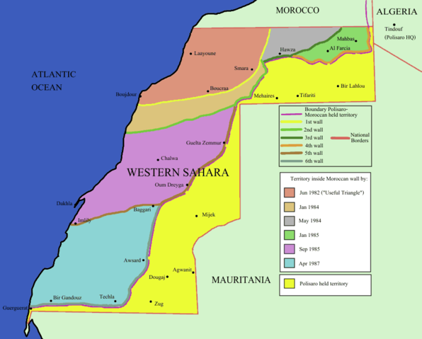
English: Map of the w:Moroccan Wall in w:Western Sahara - built over several stages, shows the six walls built, & when the territory was behind Moroccan wall. Also shows polisaro held territory who are based in Algeria (seen at top right). I made the map using UN map and this map for reference.
|
| Date |
|
| Source |
Identical PNG copy of file:Western sahara walls moroccan.gif |
| Author |
User:Roke |
Licensing
 |
Permission is granted to copy, distribute and/or modify this document under the terms of the GNU Free Documentation License, Version 1.2 or any later version published by the Free Software Foundation; with no Invariant Sections, no Front-Cover Texts, and no Back-Cover Texts. A copy of the license is included in the section entitled GNU Free Documentation License. http://www.gnu.org/copyleft/fdl.htmlGFDLGNU Free Documentation Licensetruetrue
|
Wikipedia for Schools is one of SOS Childrens Villages' many educational projects. SOS Children is there for the children in our care until they are ready for independence. There are many ways to help with SOS Children's Villages.


