
File:Cocos (Keeling) Islands-CIA WFB Map.png
Cocos_(Keeling)_Islands-CIA_WFB_Map.png (329 × 355 pixels, file size: 5 KB, MIME type: image/png)
| |
This is a file from the Wikimedia Commons. Information from its description page there is shown below.
Commons is a freely licensed media file repository. You can help. |
| Description |
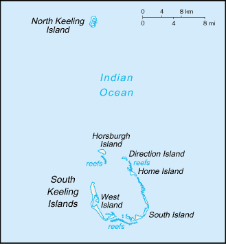
Русский: Карта Кокосовых (Килинг) островов
|
|||
| Date | ||||
| Source | https://www.cia.gov/library/publications/the-world-factbook/maps/ck-map.gif | |||
| Author | CIA World Factbook | |||
| Permission ( Reusing this file) |
|


File usage
The following pages on Schools Wikipedia link to this image (list may be incomplete):
The best way to learn
Schools Wikipedia was launched to make learning available to everyone. SOS Children's Villages works in 133 countries and territories across the globe, helps more than 62,000 children, and reaches over 2 million people in total. Have you heard about child sponsorship? Learn more...