
File:Aruba map.png
Aruba_map.png (326 × 351 pixels, file size: 7 KB, MIME type: image/png)
| |
This is a file from the Wikimedia Commons. Information from its description page there is shown below.
Commons is a freely licensed media file repository. You can help. |
Summary
 |
This map image could be recreated using vector graphics as an SVG file. This has several advantages; see Commons:Media for cleanup for more information. If an SVG form of this image is already available, please upload it. After uploading an SVG, replace this template with {{ vector version available|new image name.svg}}. |
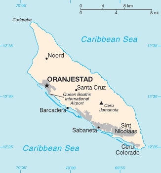
Español: Mapa de Aruba
 |
This image is in the public domain because it contains materials that originally came from the United States Central Intelligence Agency's World Factbook.
|
 |
(Delete all revisions of this file) (cur) 21:32, 24 May 2005 . . Hoshie (Talk) . . 329x354 (7769 bytes) (Updated map of Aruba from 2005 Factbook)
(del) (rev) 23:06, 29 November 2002 . . Scipius (Talk) . . 330x355 (4678 bytes) (Factbook map of Aruba)
derivative works
Derivative works of this file:
File usage
The following pages on Schools Wikipedia link to this image (list may be incomplete):
Find out more
Wikipedia for Schools was collected by SOS Children's Villages. SOS Childrens Villages is famous for the love and shelter it brings to lone children, but we also support families in the areas around our Children's Villages, helping those who need us the most. Sponsoring a child is the coolest way to help.