
File:Anguilla map.png
Anguilla_map.png (328 × 352 pixels, file size: 15 KB, MIME type: image/png)
| |
This is a file from the Wikimedia Commons. Information from its description page there is shown below.
Commons is a freely licensed media file repository. You can help. |
Summary
| Description |
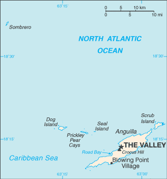
Español: Mapa de Anguila
English: Map of British overseas territory of Anguilla, comprising main eponymous island and smaller islets and cays.
|
|||
| Date | undated | |||
| Source | CIA World Factbook | |||
| Author | United States Central Intelligence Agency | |||
| Permission ( Reusing this file) |
|


File usage
The following pages on Schools Wikipedia link to this image (list may be incomplete):
Did you know...?
Wikipedia for Schools is designed to make learning fun and easy. SOS Childrens Villages is there for the children in our care until they are ready for independence. Have you thought about sponsoring a child?