
File:Easter Island map-en.svg
| |
This is a file from the Wikimedia Commons. Information from its description page there is shown below.
Commons is a freely licensed media file repository. You can help. |
Summary
 |
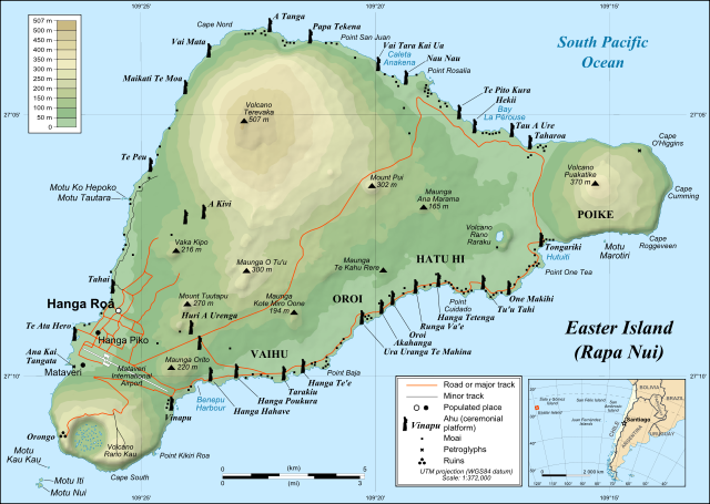
This image was selected as picture of the day on Wikimedia Commons for 1 December 2008. It was captioned as follows: English: Detailed topographic map in English of Easter Island.
Afrikaans: Gedetaileerde topografie van Paaseiland
Català: Mapa topogràfic detallat en anglès de l' Illa de Pasqua.
Česky: Detailní topografická mapa Velikonočního ostrova
Dansk: Detaljeret topografisk kort over Påskeøen på engelsk.
Deutsch: Übersichtskarte der Osterinsel; deutsche Version hier
English: Detailed topographic map in English of Easter Island.
Esperanto: detala topografia mapo de la Paskinsulo (jen anglalingva, sed ankaŭ havebla en pluraj aliaj lingvoj)
Español: Mapa topográfico detallado en inglés de la Isla de Pascua, Chile.
Eesti: Detailne inglisekeelne topograafiline kaart et:Lihavõttesaarest.
Français : Carte topographique détaillée en anglais de l' île de Pâques
Magyar: A Húsvét-sziget részletes topográfiai térképe
Italiano: Mappa topografica dell' Isola di Pasqua, Cile.
日本語: 英語による イースター島の詳細な 地形図。
한국어: 이스터 섬의 지형도.
Македонски: Детална топографска карта на Велигденскиот Остров на англиски.
Nederlands: Engelstalige gedetailleerde topografische kaart van Paaseiland
Polski: Mapa topograficzna Wyspy Wielkanocnej
Português: Mapa topográfico detalhado, em Inglês, da Ilha da Páscoa
Română: Hartă topografică detaliată, în limba engleză, a insulei Paştelui.
Русский: Топографическая карта Острова Пасхи
Svenska: Detaljerad topografisk karta på engelska över Påskön.
Українська: Детальна англомовна топографічна мапа Острову Пасхи.
中文(简体): 复活节岛地形图
中文(繁體): 復活節島地形圖
|
|
| Description |
English: Detailed topographic map in English of Easter Island
Français : Carte topographique détaillée en anglais de l' île de Paques
Português: Mapa topográfico detalhado, em Inglês, da Ilha da Páscoa.
|
| Date | October 2007 - October 2008 for the new version (see the release note) |
| Source | Own work
|
| Author | Eric Gaba ( Sting), translated by Bamse |
| Permission ( Reusing this file) |
Creative Commons: Share Alike – attribution required |
This map was improved or created by the Wikigraphists of the Graphic Lab (fr). You can propose images to clean up, improve, create or translate as well.
বাংলা | català | česky | Deutsch | Deutsch (Sie-Form) | Ελληνικά | English | Esperanto | español | suomi | français | עברית | magyar | Հայերեն | italiano | 한국어 | македонски | Bahasa Melayu | Plattdüütsch | Nederlands | occitan | polski | português | română | русский | slovenščina | svenska | татарча/tatarça | Türkçe | українська | 中文 | 中文(简体) | 中文(繁體) | Zazaki | +/−
|
|
This vector image was created with Inkscape. |
| |
This SVG file uses embedded text that can be easily translated into your language using this automated tool. Learn more. You can also download it and translate it manually using a text editor.
|
Licensing
|
File usage
Metadata
Learn more
Wikipedia for Schools was collected by SOS Children. SOS Children's Villages helps more than 2 million people across 133 countries around the world. Have you thought about sponsoring a child?