 |
This is a file from the Wikimedia Commons. Information from its description page there is shown below.
Commons is a freely licensed media file repository. You can help.
|
| Public domainPublic domainfalsefalse |
 |
This map has been uploaded by Electionworld from en.wikipedia.org to enable the  Wikimedia Atlas of the World Wikimedia Atlas of the World  . Original uploader to en.wikipedia.org was MaGioZal, known as MaGioZal at en.wikipedia.org. Electionworld is not the creator of this map. Licensing information is below. . Original uploader to en.wikipedia.org was MaGioZal, known as MaGioZal at en.wikipedia.org. Electionworld is not the creator of this map. Licensing information is below. |
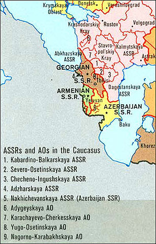
Map showing the subdivisions ( SSRs, ASSRs and autonomous oblasts) of Caucasian Soviet Union in 1989, just before the Berlin Wall fall.
This map is a detail of the map of the whole Soviet Union administrative divisions and subdivisions in 1989 edited by the University of Texas.
| Public domainPublic domainfalsefalse |
 |
This work is in the public domain in the United States because it is a work prepared by an officer or employee of the United States Government as part of that person’s official duties under the terms of Title 17, Chapter 1, Section 105 of the US Code. See Copyright. Note: This only applies to original works of the Federal Government and not to the work of any individual U.S. state, territory, commonwealth, county, municipality, or any other subdivision. This template also does not apply to postage stamp designs published by the United States Postal Service since 1978. (See 206.02(b) of Compendium II: Copyright Office Practices). It also does not apply to certain US coins; see The US Mint Terms of Use.
|
|
|
This file has been identified as being free of known restrictions under copyright law, including all related and neighboring rights.
|
Wikipedia for Schools is one of SOS Childrens Villages' many educational projects. SOS Children is an international children's charity, providing a good home and loving family to thousands of children who have lost their parents. We also work with communities to help vulnerable families stay together and raise children in the best possible environment. You can help by sponsoring a child.


