 |
This is a file from the Wikimedia Commons. Information from its description page there is shown below.
Commons is a freely licensed media file repository. You can help.
|
| Description |
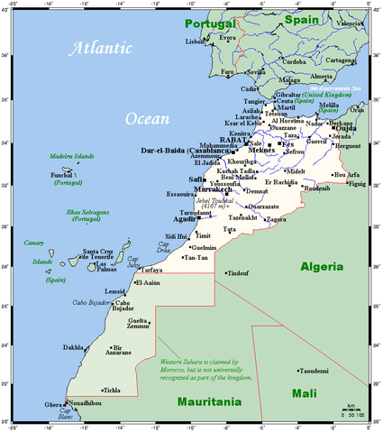
English: A map showing Morocco's and Western Sahara's cities and main towns.
|
| Date |
14 August 2007 (original upload date) |
| Source |
English: This map's source is here, with the uploader's modifications, and the GMT homepage says that the tools are released under the GNU General Public License.
|
| Author |
Original uploader was Kelisi at en.wikipedia |
Permission
( Reusing this file) |
planiglobe.com, the copyright holder of this work, hereby publishes it under the following license:
 |
Permission is granted to copy, distribute and/or modify this document under the terms of the GNU Free Documentation License, Version 1.2 or any later version published by the Free Software Foundation; with no Invariant Sections, no Front-Cover Texts, and no Back-Cover Texts. A copy of the license is included in the section entitled GNU Free Documentation License. http://www.gnu.org/copyleft/fdl.htmlGFDLGNU Free Documentation Licensetruetrue
|
|
|
File usage
The following pages on Schools Wikipedia link to this image (list may be incomplete):
Wikipedia for Schools was collected by SOS Childrens Villages. SOS Children's Villages believes that a decent childhood is essential to a happy, healthy. Our community work brings families new opportunities through education, healthcare and all manner of support. Find out how you can help children in other countries.


