
File:Ocean gravity map.gif
Size of this preview: 640 × 378 pixels.
| |
This is a file from the Wikimedia Commons. Information from its description page there is shown below.
Commons is a freely licensed media file repository. You can help. |
| Description |
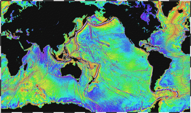
English: Ocean basins mapped with satellite altimetry. Seafloor features larger than 10 km are detected by resulting gravitational distortion of sea surface.
|
| Date | 2005 |
| Source | http://www.ngdc.noaa.gov/mgg/bathymetry/predicted/explore.HTML |
| Author | NOAA |
 |
This image is in the public domain because it contains materials that originally came from the U.S. National Oceanic and Atmospheric Administration, taken or made as part of an employee's official duties.
|
 |
File usage
The following pages on Schools Wikipedia link to this image (list may be incomplete):
About Schools Wikipedia
All five editions of Schools Wikipedia were compiled by SOS Children. SOS Childrens Villages cares for children who have lost their parents. Our Children's Villages give these children a new home and a new family, while a high-quality education and the best of medical care ensures they will grow up with all they need to succeed in adult life. Want to learn more? Go to http://www.soschildrensvillages.org.uk/sponsor-a-child