
File:1984 fictious world map v2 arr.png
Size of this preview: 640 × 325 pixels.
| |
This is a file from the Wikimedia Commons. Information from its description page there is shown below.
Commons is a freely licensed media file repository. You can help. |
Summary
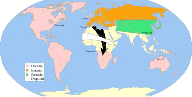
| Description | Fictitious map, illustrating the political landscape of Orwell's Nineteen-Eighty-four, approximate map of the "Black arrows" and "white arrows" described at the end of the book, rendered from Image:1984_fictious_world_map_v2.svg, inspired by Image:1984_fictious_world_map.png and Image:1984_Orwell_arrows_2.png, based on Image:BlankMap-World6.svg, created following Wikipedia's map colour standard. | ||
| Date | 14 January 2008 | ||
| Source | Own work | ||
| Author | Twisp | ||
| Permission ( Reusing this file) |
|
 |
This map image could be recreated using vector graphics as an SVG file. This has several advantages; see Commons:Media for cleanup for more information. If an SVG form of this image is already available, please upload it. After uploading an SVG, replace this template with {{ vector version available|new image name.svg}}. |
Licensing
 |
I, the copyright holder of this work, release this work into the public domain. This applies worldwide. In some countries this may not be legally possible; if so: I grant anyone the right to use this work for any purpose, without any conditions, unless such conditions are required by law.
|
File usage
The following pages on Schools Wikipedia link to this image (list may be incomplete):
Metadata
Did you know...?
Schools Wikipedia was created by children's charity SOS Childrens Villages. SOS Children helps more than 2 million people across 133 countries around the world. Have you thought about sponsoring a child?