
File:1984 fictitious world map v2 quad.svg
Size of this preview: 640 × 325 pixels.
| |
This is a file from the Wikimedia Commons. Information from its description page there is shown below.
Commons is a freely licensed media file repository. You can help. |
Summary
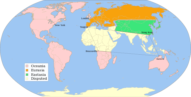
| Description | Fictitious map, illustrating the political landscape of Orwell's Nineteen Eighty-Four, based on Image:1984_fictious_world_map_v2_quad.png, rendered from Image:1984_fictious_world_map_v2.svg, inspired by Image:1984_fictious_world_map.png and Image:1984_Orwell_arrows_2.png, based on Image:BlankMap-World6.svg, created following Wikipedia's map colour standard. | ||
| Date | 21 March 2008 | ||
| Source | Twisp | ||
| Author | MichaelsProgramming | ||
| Permission ( Reusing this file) |
|

![]() ✓ The source code of this SVG is valid.
✓ The source code of this SVG is valid.
File usage
The following pages on Schools Wikipedia link to this image (list may be incomplete):
Metadata
Learn more
All five editions of Schools Wikipedia were compiled by SOS Childrens Villages. SOS Children is a global charity founded in 1949 to give children who have lost everything the childhood they deserve. Learn more about child sponsorship.