
File:Saltlaketornado.jpeg
Saltlaketornado.jpeg (320 × 242 pixels, file size: 81 KB, MIME type: image/jpeg)
| |
This is a file from the Wikimedia Commons. Information from its description page there is shown below.
Commons is a freely licensed media file repository. You can help. |
|
Camera location |
|
This and other images at their locations on: Google Maps - Google Earth - OpenStreetMap | ( Info) |
|---|
 |
This image is in the public domain because it was stored on the web servers of the U.S. National Weather Service. NWS-created images are automatically public domain since the NWS is a part of the US government. However, the NWS sites also host non-NWS images which have been submitted by individuals: these are generally shown as "Courtesy of ...". Such images have explicitly been released to the public domain by the copyright owner as part of the upload process: see for example here, here, here and here. As stated at http://www.weather.gov/disclaimer.php:"The information on government servers are in the public domain, unless specifically annotated otherwise, and may be used freely by the public....".
|
 |
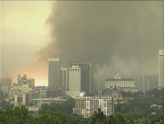
Tornado in downtown Salt Lake City, Utah, United States.
1999
Salt Lake City Tornado, August 11, 1999. (Orange fireball is a power sub-station exploding) Photo given to NOAA for public use by KTVX News 4 Utah
File usage
The following pages on Schools Wikipedia link to this image (list may be incomplete):
Metadata
About Schools Wikipedia
You can learn about nearly 6,000 different topics on Schools Wikipedia. SOS Children helps more than 2 million people across 133 countries around the world. We have helped children in Africa for many years - you can help too...