
File:Super Outbreak Map.jpg
Size of this preview: 395 × 479 pixels.
| |
This is a file from the Wikimedia Commons. Information from its description page there is shown below.
Commons is a freely licensed media file repository. You can help. |
 |
This map image could be recreated using vector graphics as an SVG file. This has several advantages; see Commons:Media for cleanup for more information. If an SVG form of this image is already available, please upload it. After uploading an SVG, replace this template with {{ vector version available|new image name.svg}}. |
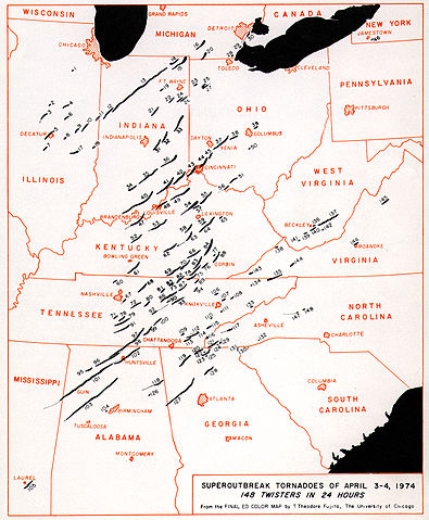
Tracks of tornadoes generated during the 1974 Super Outbreak.
From the National Weather Service, Courtesy of Ted Fujita ( actual image link)
 |
This image is in the public domain because it was stored on the web servers of the U.S. National Weather Service. NWS-created images are automatically public domain since the NWS is a part of the US government. However, the NWS sites also host non-NWS images which have been submitted by individuals: these are generally shown as "Courtesy of ...". Such images have explicitly been released to the public domain by the copyright owner as part of the upload process: see for example here, here, here and here. As stated at http://www.weather.gov/disclaimer.php:"The information on government servers are in the public domain, unless specifically annotated otherwise, and may be used freely by the public....".
|
 |
File usage
The following pages on Schools Wikipedia link to this image (list may be incomplete):
Metadata
Find out more
Wikipedia for Schools was collected by SOS Children. SOS Children believes that a decent childhood is essential to a happy, healthy. Our community work brings families new opportunities through education, healthcare and all manner of support. There are many ways to help with SOS Children.