 |
This is a file from the Wikimedia Commons. Information from its description page there is shown below.
Commons is a freely licensed media file repository. You can help.
|
Summary
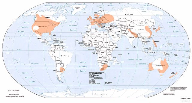
Shows where tornadoes are most likely to occur.
From the website of the National Climatic Data Centre, Asheville, North Carolina, http://www.ncdc.noaa.gov/oa/climate/severeweather/tornadoes.html
Image location: http://www.ncdc.noaa.gov/img/climate/research/tornado/globdist.jpg
 |
This image was uploaded in the JPEG format even though it consists of non-photographic data. This information could be stored more efficiently or accurately in the PNG format or SVG format. If possible, please upload a PNG or SVG version of this image without compression artifacts, derived from a non-JPEG source (or with existing artifacts removed). After doing so, please tag the JPEG version with {{ Superseded|NewImage.ext}}, and remove this tag. This tag should not be applied to photographs or scans. For more information, see {{ BadJPEG}}. |
|
|
Licensing
| Public domainPublic domainfalsefalse |
 |
This image is in the public domain because it contains materials that originally came from the U.S. National Oceanic and Atmospheric Administration, taken or made as part of an employee's official duties.
|
|
File usage
The following pages on Schools Wikipedia link to this image (list may be incomplete):
This file contains additional information, probably added from the digital camera or scanner used to create or digitize it. If the file has been modified from its original state, some details may not fully reflect the modified file.
Wikipedia for Schools is one of SOS Children's Villages' many educational projects. SOS Childrens Villages helps those who have nothing and no one, giving them back the famly they have lost and bringing them the very best opportunities for a happy, healthy future. Would you like to sponsor a child?


