
File:Miss R dam 27.jpg
| |
This is a file from the Wikimedia Commons. Information from its description page there is shown below.
Commons is a freely licensed media file repository. You can help. |
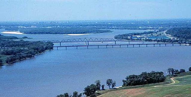
The Mississippi River, looking south toward the city of St. Louis from near the confluence with the Missouri River; showing the Interstate 270 Bridge, the old Chain of Rocks Bridge (which once carried Route 66), city water intake towers, a low water dam (dam 27) and the St. Louis waterworks.
The Chain of Rocks Canal bypasses this section of the river. There are no dams on the river between dam 26 and the Gulf of Mexico.
This photograph was obtained from U.S. Geological Survey's Upper Midwest Environmental Sciences Centre website.
 |
This image is in the public domain because it contains materials that originally came from the United States Geological Survey, an agency of the United States Department of the Interior. For more information, see the official USGS copyright policy. български | català | Deutsch | English | español | eesti | suomi | français | galego | italiano | 한국어 | македонски | മലയാളം | Nederlands | polski | português | русский | Türkçe | 中文 | 中文(简体) | +/− |
|
File usage
Learn more about Schools Wikipedia
Schools Wikipedia was launched to make learning available to everyone. SOS Children's Villages believes education is an important part of a child's life. That's why we ensure they receive nursery care as well as high-quality primary and secondary education. When they leave school, we support the children in our care as they progress to vocational training or higher education. Go to http://www.soschildrensvillages.org.uk/sponsor-a-child to sponsor a child.