 |
This is a file from the Wikimedia Commons. Information from its description page there is shown below.
Commons is a freely licensed media file repository. You can help.
|
Summary
| Description |
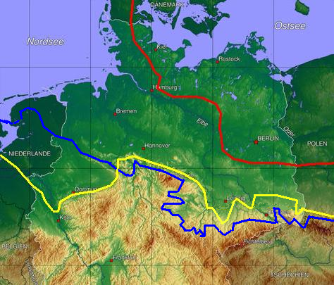
English: Ice age map of europe, red: maximum limit of Weichselian ice age, yellow Saale-ice age at maximum (Drenthe stage), blue Elster-ice age maximum glaciation.
Deutsch:
- jeweils maximale Ausdehnung der drei letzten Eiszeiten (Erweiterte Karte nach der Originalkarte File:EisrandlagenNorddeutschland.jpg von Benutzer:Fice)
- Selbst gezeichnet (ergänzt) und hochgeladen von Botaurus
- Datenquelle: www.uni-muenster und für den östlichsten Bereich: Wagenbreth/Steiner "Geologische Streifzüge" VEB Deutscher Verlag für Grundstoffindustrie, 2. Aufl. Leipzig 1985
|
| Date |
25 July 2006 (original upload date) |
| Source |
Originally from de.wikipedia; description page is/was here. |
| Author |
Original uploader was Botaurus at de.wikipedia |
Licensing
| Public domainPublic domainfalsefalse |
 |
This work has been released into the public domain by its author, Botaurus at the wikipedia project. This applies worldwide.
In case this is not legally possible:
Botaurus grants anyone the right to use this work for any purpose, without any conditions, unless such conditions are required by law.
|
File usage
The following pages on Schools Wikipedia link to this image (list may be incomplete):
SOS Childrens Villages chose the best bits of Wikipedia to help you learn. SOS Children's Villages believes that a decent childhood is essential to a happy, healthy. Our community work brings families new opportunities through education, healthcare and all manner of support. You can help by sponsoring a child.


