 |
This is a file from the Wikimedia Commons. Information from its description page there is shown below.
Commons is a freely licensed media file repository. You can help.
|
 |
This map image could be recreated using vector graphics as an SVG file. This has several advantages; see Commons:Media for cleanup for more information. If an SVG form of this image is already available, please upload it. After uploading an SVG, replace this template with {{ vector version available|new image name.svg}}. |
| Description |
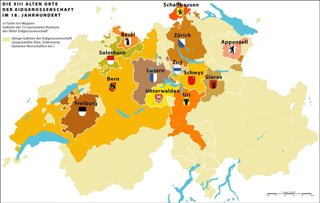
Deutsch: Die 13 «Alten Orte» (alte Kantone) der schweizerischen Eidgenossenschaft und ihr direkt beherrschtes Territorium im 18. Jahrhundert
|
| Date |
3.5.2007 |
| Source |
Own work |
| Author |
Marco Zanoli ( sidonius 19:14, 3 May 2007 (UTC)) |
Permission
( Reusing this file) |
|
You may use my work outside wikipedia for free as long as you name me as the author in the following way: wikipedia, Marco Zanoli. If you want to use my work in a print medium, please send me a specimen copy. Contact me for further questions on wikipedia.de or via email (mzanoli at bluewin.ch).
|
|
File usage
The following pages on Schools Wikipedia link to this image (list may be incomplete):
Schools Wikipedia has been carefully checked to give you the best learning experience. Our 500 Children's Villages provide a home for thousands of vulnerable children. Beyond our Villages, we support communities, helping local people establish better schools and delivering effective medical care to vulnerable children. There are many ways to help with SOS Childrens Villages.


