
File:U.S. Territorial Acquisitions.png
Size of this preview: 640 × 433 pixels.
| |
This is a file from the Wikimedia Commons. Information from its description page there is shown below.
Commons is a freely licensed media file repository. You can help. |
| Description |
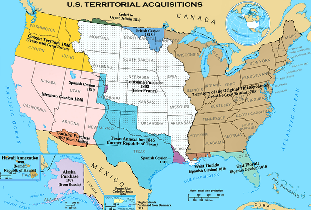
English: The Territorial acquisitions of the United States, such as the Thirteen Colonies, the Louisiana Purchase, British and Spanish Cession, and so on.
|
|||
| Date | 1970, 2006 | |||
| Source | National Atlas of the United States | |||
| Author | United States federal government ( en:User:Black and White converted it from JPEG to PNG and retouched it) | |||
| Permission ( Reusing this file) |
|


 |
This map image could be recreated using vector graphics as an SVG file. This has several advantages; see Commons:Media for cleanup for more information. If an SVG form of this image is already available, please upload it. After uploading an SVG, replace this template with {{ vector version available|new image name.svg}}. |
(Uploaded using CommonsHelper or PushForCommons)
Possible Errors
There is a concern that this map could have errors. For discussion, please see the en:Image talk:U.S. Territorial Acquisitions.png talk page.
File usage
The following pages on Schools Wikipedia link to this image (list may be incomplete):
Metadata
What is Schools Wikipedia?
Schools Wikipedia was created by children's charity SOS Children. SOS Childrens Villages is there for the children in our care until they are ready for independence. Go to http://www.soschildrensvillages.org.uk/sponsor-a-child to sponsor a child.