
File:AralSeaAug1964-keyhole.jpg
- File
- File usage
- The best way to learn
| |
This is a file from the Wikimedia Commons. Information from its description page there is shown below.
Commons is a freely licensed media file repository. You can help. |
| Description |
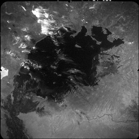
English: This image of the Aral Sea was acquired in August of 1964 by a United States Argon intelligence mapping/geodesy satellite.
KH-5 Mission 9064-A (incorrectly mislabeled 9066-A in the USGS archive) carried the A-22 mapping camera. A TAT-Agena carried this camera into an orbit of 114.96 degrees of inclination with a period of 84 minutes, a perigee of 219 degrees and an apogee of 232 degrees. International Launch Designation: 1964-043A Launch Date: August 21, 1964 Mission Duration: approximately 6 days |
| Date | 2006-07-05 (original upload date) |
| Source | Transferred from en.wikipedia |
| Author | Original uploader was Hartze11 at en.wikipedia |
| Permission ( Reusing this file) |
PD-USGOV. |
Licensing
 |
This work is in the public domain in the United States because it is a work prepared by an officer or employee of the United States Government as part of that person’s official duties under the terms of Title 17, Chapter 1, Section 105 of the US Code. See Copyright. Note: This only applies to original works of the Federal Government and not to the work of any individual U.S. state, territory, commonwealth, county, municipality, or any other subdivision. This template also does not apply to postage stamp designs published by the United States Postal Service since 1978. (See 206.02(b) of Compendium II: Copyright Office Practices). It also does not apply to certain US coins; see The US Mint Terms of Use. |
 |
|
|
||
The best way to learn
Through Schools Wikipedia, SOS Children's Villages has brought learning to children around the world. SOS Children helps more than 2 million people across 133 countries around the world. Find out how you can help children in other countries.