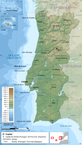
File:Portugal topographic map-pt.png

| |
This is a file from the Wikimedia Commons. Information from its description page there is shown below.
Commons is a freely licensed media file repository. You can help. |
| DescriptionPortugal topographic map-pt.png |
Français : Carte topographique et administrative en portugais du Portugal
Português: Carta topográfica e da administração do Portugal, em português
Deutsch: Topographische Karte von Portugal, portugiesische Version
English: Topographic and administrative map in Portuguese of Portugal
Español: Mapa topográfico y administrativo en portugés del Portugal
Italiano: Carta topografica e amministrativa de Portogallo
日本語: ポルトガル語で表示した ポルトガル地形·行政地図
|
||||||||
| Date | 14 June 2009 | ||||||||
| Source |
English: Own work ;
Français : Création personnelle ;
|
||||||||
| Author | Bourrichon - fr:Bourrichon | ||||||||
| Permission ( Reusing this file) |
|
This map was improved or created by the Wikigraphists of the Graphic Lab (fr). You can propose images to clean up, improve, create or translate as well.
বাংলা | català | česky | Deutsch | Deutsch (Sie-Form) | Ελληνικά | English | Esperanto | español | suomi | français | עברית | magyar | Հայերեն | italiano | 한국어 | македонски | Bahasa Melayu | Plattdüütsch | Nederlands | occitan | polski | português | română | русский | slovenščina | svenska | татарча/tatarça | Türkçe | українська | 中文 | 中文(简体) | 中文(繁體) | Zazaki | +/−
File usage
Wikipedia for Schools...
Wikipedia for Schools is one of SOS Children's many educational projects. More than 2 million people benefit from the global charity work of SOS Childrens Villages, and our work in 133 countries around the world is vital to ensuring a better future for vulnerable children. There are many ways to help with SOS Childrens Villages.

