
File:Map of Finland-en.svg
Size of this preview: 327 × 479 pixels.
| |
This is a file from the Wikimedia Commons. Information from its description page there is shown below.
Commons is a freely licensed media file repository. You can help. |
|
|
This vector image was created with Inkscape. |
Summary
| Description |
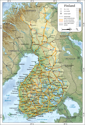
English: Map of Finland.
Suomi: Suomen kartta.
Svenska: Karta över Finland.
|
| Date | 5 March 2009 |
| Source | Self-made in Inkscape.
|
| Author | Oona Räisänen ( Mysid) |
| Permission ( Reusing this file) |
See below. I've worked hard to create this map, so even though not mandatory, please attribute me wherever it is suitable. |
| |
This SVG file uses embedded text that can be easily translated into your language using this automated tool. Learn more. You can also download it and translate it manually using a text editor.
|
Licensing
 |
I, the copyright holder of this work, release this work into the public domain. This applies worldwide. In some countries this may not be legally possible; if so: I grant anyone the right to use this work for any purpose, without any conditions, unless such conditions are required by law.
|
File usage
The following pages on Schools Wikipedia link to this image (list may be incomplete):
Metadata
Did you know...?
Wikipedia for Schools is designed to make learning fun and easy. SOS Children's Villages believes that a decent childhood is essential to a happy, healthy. Our community work brings families new opportunities through education, healthcare and all manner of support. We have helped children in Africa for many years - you can help too...