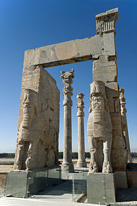
File:20101229 Top panoramic view of Persepolis Iran.jpg

Size of this preview: 640 × 181 pixels.
| |
This is a file from the Wikimedia Commons. Information from its description page there is shown below.
Commons is a freely licensed media file repository. You can help. |
Summary
| Description20101229 Top panoramic view of Persepolis Iran.jpg |
English: Persepolis panorama - Iran.
Ελληνικά: Πανοραμική εικόνα Περσέπολης - Ιράν.
|
| Date | 29 December 2010, 10:51:02 |
| Source | Own work |
| Author | User:Ggia |
| Permission ( Reusing this file) |
Creative Commons License 3.0 Share-Alike |
|
Camera location |
29° 56′ 10.64″ N, 52° 53′ 32.54″ E |
View this and other nearby images on: Google Maps - Google Earth - OpenStreetMap | ( Info)29.93629;52.8923716666 |
|---|
Licensing
|
| Annotations | This image is annotated: View the annotations at Commons |
4430
504
249
223
6700
1893

English: Gate of all Nations.
Ελληνικά: Η πύλη των Εθνών.
File usage
The following pages on Schools Wikipedia link to this image (list may be incomplete):
Metadata
This file contains additional information, probably added from the digital camera or scanner used to create or digitize it. If the file has been modified from its original state, some details may not fully reflect the modified file.
| Image title |
|
|---|---|
| Camera manufacturer | NIKON CORPORATION |
| Camera model | NIKON D700 |
| Author | {georgios.giannopoulos at gmail.com} |
| Copyright holder |
|
| Date and time of data generation | 10:51, 29 December 2010 |
| Latitude | 29° 56′ 10.64″ N |
| Longitude | 52° 53′ 32.54″ E |
| Altitude | 1,676 meters above sea level |
| Orientation | Normal |
| Horizontal resolution | 300 dpi |
| Vertical resolution | 300 dpi |
| File change date and time | 11:58, 7 February 2011 |
| Exif version | 2.2 |
| Date and time of digitizing | 10:51, 29 December 2010 |
| Meaning of each component | Y |
| DateTime subseconds | 0 |
| DateTimeOriginal subseconds | 0 |
| DateTimeDigitized subseconds | 0 |
| Supported Flashpix version | 0,100 |
| Colour space | sRGB |
| GPS time (atomic clock) | 07:51 |
| Satellites used for measurement | 09 |
| Geodetic survey data used | WGS 84 |
| GPS date | 29 December 2010 |
| GPS tag version | 0.0.2.2 |
| Serial number of camera | 2080897 |
| Image width | 1,893 px |
| Image height | 6,700 px |
| Date metadata was last modified | 13:58, 7 February 2011 |
| Unique ID of original document | xmp.did:570C225FA032E011B159E2053FC43953 |
I want to learn more...
SOS Children has brought Wikipedia to the classroom. SOS Childrens Villages believes that a decent childhood is essential to a happy, healthy. Our community work brings families new opportunities through education, healthcare and all manner of support. Go to http://www.soschildrensvillages.org.uk/sponsor-a-child to sponsor a child.
