
File:South Africa - population migrations.svg
| |
This is a file from the Wikimedia Commons. Information from its description page there is shown below.
Commons is a freely licensed media file repository. You can help. |
Summary
| Description |
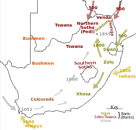
English: Map of the migrations that formed the many Ethnic groups and races in South Africa.
Français : Carte des migrations qui ont formé les nombreuses races et groupes éthniques de l' Afrique du Sud.
|
| Date | 01/11/2008 |
| Source | Own work |
| Author | Chris DHDR |
|
Camera location |
|
View this and other nearby images on: Google Maps - Google Earth - OpenStreetMap | ( Info) |
|---|
Licensing
|
File usage
The following pages on Schools Wikipedia link to this image (list may be incomplete):
Metadata
Find out more
Schools Wikipedia has been carefully checked to give you the best learning experience. By supporting vulnerable children right through to adulthood, SOS Childrens Villages makes a lasting difference to the lives of thousands of people. Education is a key part of our work, and our schools provide high-quality teaching to the children in our care. You can help by sponsoring a child.