
File:View from Mangart MC.jpg
Size of this preview: 639 × 223 pixels.
| |
This is a file from the Wikimedia Commons. Information from its description page there is shown below.
Commons is a freely licensed media file repository. You can help. |
|
Summary
| Description |
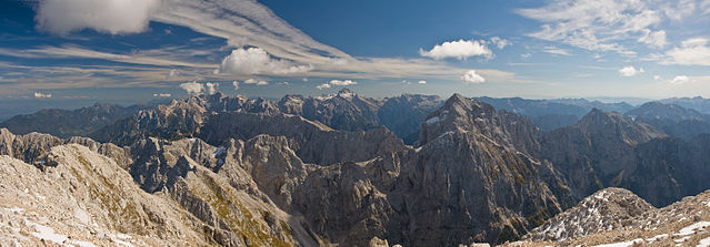
Česky: Pohled z vrcholu Mangartu (2679m) ve směru Triglavského národního parku. Uprostřed vzadu je vrchol Triglavu (2864m), nejvyšší hory Slovinska. Panoráma je sestavené ze tří fotografií za pomoci PTGUI .
Deutsch: Blick vom Gipfel des Mangart (2679m) in Richtung des Triglav Nationalparks. Der Gipfel des Triglav (2864m), der höchste Berg in Slowenien ist in der Mitte des Bildes im Hintergrund erkennbar. Panorama zusammengesetzt aus drei Querformatbildern mittels PTGUI .
English: View from top of the Mangart (2679m) to Triglav National Park. Triglav (2864m), the highest mountain in Slovenia is seen in the background in the middle of the image. Panorama stitched from three landscape format images using PTGUI .
Français : Vue depuis le sommet du mont Mangart (2679m) sur le parc national du Triglav. Le sommet du Triglav, point culminant de la Slovénie, est visible au fond et au centre de l'image. Image panoramique obtenue en assemblant trois clichés avec PTGUI .
Русский: Вид с вершины горы Мангарт (2679м) на национальный парк Триглав. Вершина Триглава (2864м), высочайшей вершины Словении, находится по центру заднего плана. Панорама составлена из трёх фотографий с использованием PTGUI .
Slovenščina: Pogled z Mangrta proti vzhodu (od leve proti desni so vidni Ponca, Špikova skupina, Mojstrovka, Škrlatica, Razor, Prisank, Travnik, Triglav, Kanjavec, Jalovec (v ospredju), Lepo špičje, ...
Українська: Вид з вершини гори Мангарт (2679м) на Національний Парк Триглав. Вершина Триглава (2864м), найвищої вершини Словенії, знаходиться у центрі заднього плану. Панораму складено из трьох фотографій за допомогою PTGUI .
|
| Date | 23 September 2007 |
| Source | Own work |
| Author | Christian Mehlführer |
|
Camera location |
|
View this and other nearby images on: Google Maps - Google Earth - OpenStreetMap | ( Info) |
|---|
Licensing
|
File usage
The following pages on Schools Wikipedia link to this image (list may be incomplete):
Metadata
Want to know more?
Through Schools Wikipedia, SOS Children's Villages has brought learning to children around the world. SOS Children's Villages believes education is an important part of a child's life. That's why we ensure they receive nursery care as well as high-quality primary and secondary education. When they leave school, we support the children in our care as they progress to vocational training or higher education. Go to http://www.soschildrensvillages.org.uk/sponsor-a-child to sponsor a child.