 |
This is a file from the Wikimedia Commons. Information from its description page there is shown below.
Commons is a freely licensed media file repository. You can help.
|
| DescriptionBahrain municipalities numbered.png |
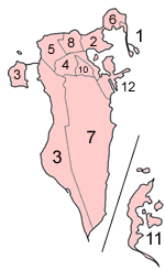
Map of the municipalities of Bahrain (which existed until 2002), numbered in English alphabetical order (using a straight transliteration, rather than translation)
- Madinat Hamad (not on map; was created in 1991 and no proper reference material with it was found at the time this map was made)
The Hawar islands are more distant than shown in this map, hence the line.
|
| Date |
18 December 2004 |
| Source |
Self-made, traced from public domain UN or CIA maps, with information from the Bahrain government. |
| Author |
User:Golbez |
Permission
( Reusing this file) |
Provide attribution, please. See below.
|
I, the copyright holder of this work, hereby publish it under the following licenses:
 |
Permission is granted to copy, distribute and/or modify this document under the terms of the GNU Free Documentation License, Version 1.2 or any later version published by the Free Software Foundation; with no Invariant Sections, no Front-Cover Texts, and no Back-Cover Texts. A copy of the license is included in the section entitled GNU Free Documentation License. http://www.gnu.org/copyleft/fdl.htmlGFDLGNU Free Documentation Licensetruetrue
|
You may select the license of your choice.
|
File usage
The following pages on Schools Wikipedia link to this image (list may be incomplete):
SOS Childrens Villages aims to make Wikipedia suitable for young learners. SOS Children's Villages is famous for the love and shelter it brings to lone children, but we also support families in the areas around our Children's Villages, helping those who need us the most. Would you like to sponsor a child?


