 |
This is a file from the Wikimedia Commons. Information from its description page there is shown below.
Commons is a freely licensed media file repository. You can help.
|
Summary
| DescriptionLocation-Asia-UNsubregions.png |
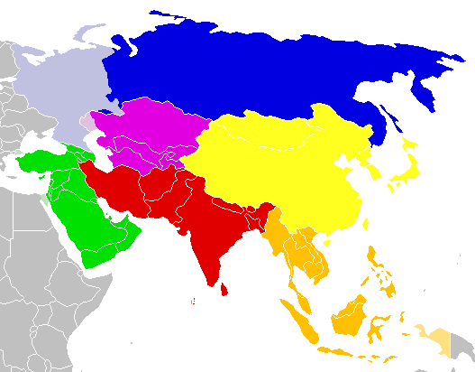
Map: Asia (location), subregions as delineated by United Nations geographic classification scheme, except *:
Northern Asia*
en:Central Asia
Western Asia
-
territories geographically, wholly or partially, in Eastern Europe, Southern Europe, and Northern Africa
Southern Asia
Eastern Asia
Southeastern Asia
|
| Date |
6.04.2006 - 1.10.2006 |
| Source |
en:Image:Location-Asia-UNsubregions.png |
| Author |
This file is lacking author information.
|
แผนที่ : เอเชีย United Nations geographic classification scheme
เอเชียเหนือ*
เอเชียกลาง
เอเชียตะวันตก
เอเชียใต้
เอเชียตะวันออก
เอเชียตะวันออกเฉียงใต้
 |
This map image could be recreated using vector graphics as an SVG file. This has several advantages; see Commons:Media for cleanup for more information. If an SVG form of this image is already available, please upload it. After uploading an SVG, replace this template with {{ vector version available|new image name.svg}}. |
Licensing
| Public domainPublic domainfalsefalse |
 |
This work has been released into the public domain by its author, E Pluribus Anthony at the English Wikipedia project. This applies worldwide.
In case this is not legally possible:
E Pluribus Anthony grants anyone the right to use this work for any purpose, without any conditions, unless such conditions are required by law.
|
History on English Wikipedia
- (Delete all revisions of this file) (cur) 17:01, 1 October 2006 . . Cogito ergo sumo (Talk | contribs | block) . . 527×412 (13,263 bytes) (Map: Asia (location), subregions)
- (del) (rev) 04:20, 28 September 2006 . . Cogito ergo sumo (Talk | contribs | block) . . 527×412 (13,272 bytes) (Map: Asia (location), subregions)
- (del) (rev) 00:24, 3 September 2006 . . Cogito ergo sumo (Talk | contribs | block) . . 527×412 (13,301 bytes) (Map: Asia (location), subregions)
- (del) (rev) 11:25, 14 April 2006 . . E Pluribus Anthony (Talk | contribs | block) . . 527×412 (13,302 bytes) (Map: Asia (location), subregions)
- (del) (rev) 10:06, 14 April 2006 . . E Pluribus Anthony (Talk | contribs | block) . . 527×412 (13,290 bytes) (Map: Asia (location), subregions)
- (del) (rev) 02:36, 6 April 2006 . . E Pluribus Anthony (Talk | contribs | block) . . 527×412 (13,278 bytes) (Map: Asia (location), subregions)
- (del) (rev) 01:40, 6 April 2006 . . E Pluribus Anthony (Talk | contribs | block) . . 527×412 (13,319 bytes) (Map: Asia (location), subregions)
File usage
The following pages on Schools Wikipedia link to this image (list may be incomplete):
Wikipedia for Schools is designed to make learning fun and easy. Thanks to SOS Childrens Villages, 62,000 children are enjoying a happy childhood, with a healthy, prosperous future ahead of them. Find out more about sponsoring a child.


