 |
This is a file from the Wikimedia Commons. Information from its description page there is shown below.
Commons is a freely licensed media file repository. You can help.
|
 |
This map image could be recreated using vector graphics as an SVG file. This has several advantages; see Commons:Media for cleanup for more information. If an SVG form of this image is already available, please upload it. After uploading an SVG, replace this template with {{ vector version available|new image name.svg}}. |
| DescriptionAustralia-climate-map MJC01.png |
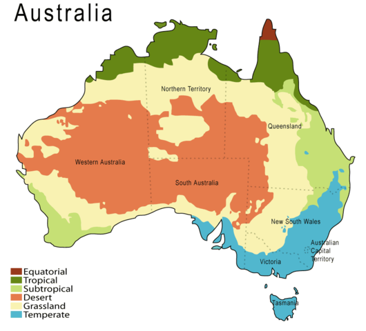
English: A climate map of Australia.
|
| Date |
|
| Source |
English: Based on a map from the Australian Bureau of Meteorology http://www.bom.gov.au. See: Australian climate zones - major classification groups (based on the Köppen classification)
|
| Author |
Martyman at en.wikipedia |
|
NOTE: "subject to disclaimers" below may not actually apply, this was tagged with {{ GFDL-user-en}}, and after May 2007, en:Template:GFDL-self did not require disclaimers. Please check the image description page on the English Wikipedia (or, if it has been deleted, ask an English Wikipedia administrator). See Wikipedia:GFDL standardization for details.
|
Martyman at the English language Wikipedia, the copyright holder of this work, hereby publishes it under the following license:
 |
Permission is granted to copy, distribute and/or modify this document under the terms of the GNU Free Documentation License, Version 1.2 or any later version published by the Free Software Foundation; with no Invariant Sections, no Front-Cover Texts, and no Back-Cover Texts. A copy of the license is included in the section entitled GNU Free Documentation License. http://www.gnu.org/copyleft/fdl.htmlGFDLGNU Free Documentation Licensetruetrue
|
|
|
|
Note: This tag should not be used. For images that were released on the English Wikipedia using either GFDL or GFDL-self with disclaimers, use {{ GFDL-user-en-with-disclaimers}}. For images without disclaimers please use {{ GFDL-user-en-no-disclaimers}} instead. If you are the copyright holder of files that were released on Wikipedia, please consider removing the disclaimers.
|
(del) (cur) 02:38, 26 September 2005 . . Martyman (Talk) . . 1000x905 (41677 bytes) (Upload new version at higher resolution and slightly changed colours.)
(del) (rev) 00:15, 26 August 2005 . . Martyman (Talk) . . 800x724 (33965 bytes) (A climate map of Australia drawn be me in Illustrator {{GFDL}})
File usage
The following pages on Schools Wikipedia link to this image (list may be incomplete):
This file contains additional information, probably added from the digital camera or scanner used to create or digitize it. If the file has been modified from its original state, some details may not fully reflect the modified file.


