
File:Map of Constantinople (1422) by Florentine cartographer Cristoforo Buondelmonte.jpg
Size of this preview: 380 × 479 pixels.
| |
This is a file from the Wikimedia Commons. Information from its description page there is shown below.
Commons is a freely licensed media file repository. You can help. |
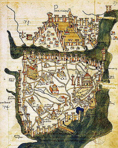
| Description | Map of Constantinople (modern Istanbul), designed in 1422 by Florentine cartographer Cristoforo Buondelmonti (Description des îles de l'archipel, Bibliothèque nationale, Paris) is the oldest surviving map of the city, and the only surviving map which predates the Turkish conquest of Constantinople in 1453. | ||||
| Date | 1422 | ||||
| Source | Liber insularum Archipelagi (1824), version available at the Bibliothèque nationale de France, Paris | ||||
| Author | Cristoforo Buondelmonti | ||||
| Permission ( Reusing this file) |
|
||||

File usage
The following pages on Schools Wikipedia link to this image (list may be incomplete):
Metadata
Learn more
Schools Wikipedia was created by children's charity SOS Children's Villages. SOS Children is a global charity founded in 1949 to give children who have lost everything the childhood they deserve. Would you like to sponsor a child?