 |
This is a file from the Wikimedia Commons. Information from its description page there is shown below.
Commons is a freely licensed media file repository. You can help.
|
 |
This map image could be recreated using vector graphics as an SVG file. This has several advantages; see Commons:Media for cleanup for more information. If an SVG form of this image is already available, please upload it. After uploading an SVG, replace this template with {{ vector version available|new image name.svg}}. |
| Description |
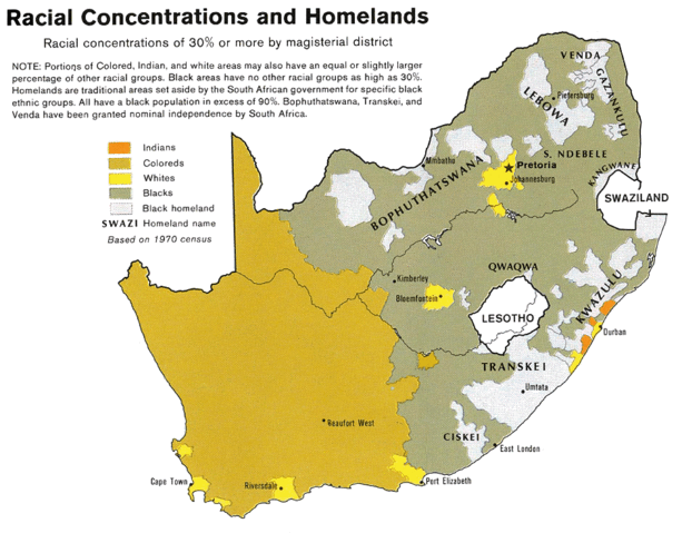
English: Map showing the territorial four main races/ethnicities/colors of South Africa in 1979: Whites, Coloureds, Blacks and Indians. The gray areas indicate the Apartheid-era Bantustans, which are almost exclusively black. This map is a photoshopped version of the CIA-made original map at Perry Castañeda map collection at the University of Texas website.
|
| Date |
1979
(23 August 2008 (original upload date)) |
| Source |
Transferred from en.wikipedia; transferred to Commons by User:Magnus Manske using CommonsHelper.
(Original text : * Site: Perry-Castañeda Library Map Collection: South Africa Maps
- Image: South Africa - Racial Concentrations and Homelands 1979 from Map No. 503971 1979)
|
| Author |
U.S. Central Intelligence Agency. Original uploader was MaGioZal at en.wikipedia |
Permission
( Reusing this file) |
PD-USGOV-CIA.
(Original text : Public domain)
|
Licensing
 |
This image is a copy or a derivative work of http://www.lib.utexas.edu/maps/africa/south_africa_racial_1979.jpg, from the map collection of the Perry-Castañeda Library (PCL) of the University of Texas at Austin.
This tag does not indicate the copyright status of the attached work. A normal copyright tag is still required. See Commons:Licensing for more information. |
| Public domainPublic domainfalsefalse |
 |
This image is a work of a Central Intelligence Agency employee, taken or made as part of that person's official duties. As a Work of the United States Government, this image or media is in the public domain.
|
 |
 |
This map image could be recreated using vector graphics as an SVG file. This has several advantages; see Commons:Media for cleanup for more information. If an SVG form of this image is already available, please upload it. After uploading an SVG, replace this template with {{ vector version available|new image name.svg}}. |
{{tlx|...}}
File usage
The following pages on Schools Wikipedia link to this image (list may be incomplete):
Schools Wikipedia was created by children's charity SOS Children. In 133 nations around the world, SOS Children's Villages works to bring better education and healthcare to families in desperate need of support. Will you help another child today?


