 |
This is a file from the Wikimedia Commons. Information from its description page there is shown below.
Commons is a freely licensed media file repository. You can help.
|
after a map by Gyrofrog.
| Description |
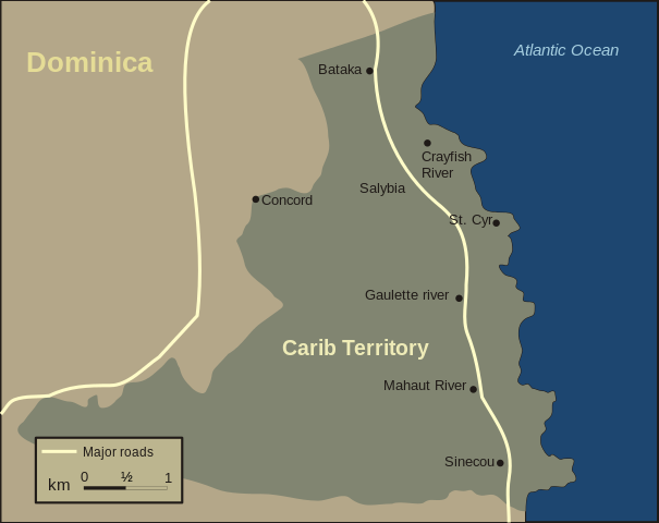
English: Map of Carib Territory on the Island of Dominica
Some 3,000 Kalinago live within Carib Territory, which stretches for almost 15 km along Dominica's northeastern coast. A paved coastal highway links the territory's eight hamlets: Bataka, Crayfish River, Salybia, St. Cyr, Gaulette River, Mahaut River, Sinecou and Concord.
fr: Territoire des Caribs sur l'île de la Dominique, Archipel des Caraïbes. Quelques 3.000 Kalinago vivent dans le territoire des Caribs, qui s'étend sur presque 15 kilomètres le long de la côte du nord-est de la Dominique, dans l'archipel des Caraïbes. Une route côtière pavée lie les huit hameaux du territoire : Bataka, Rivière d'écrevisses, Salybia, St Cyr, Rivière de Gaulette, Rivière de Mahaut, Sinecou et Accord.
|
| Date |
8 February 2007 |
| Source |
Own work |
| Author |
Hans Hillewaert |
Permission
( Reusing this file) |
|
I, the copyright holder of this work, hereby publish it under the following license:
|
|
| Other licenses |
Less restrictive terms are negotiable . |
Attribution
( required by the license) |
© Hans Hillewaert / CC-BY-SA-3.0 |
File usage
The following pages on Schools Wikipedia link to this image (list may be incomplete):
This file contains additional information, probably added from the digital camera or scanner used to create or digitize it. If the file has been modified from its original state, some details may not fully reflect the modified file.


