
File:ACW Chattanooga2Carolinas.png
Size of this preview: 640 × 341 pixels.
| |
This is a file from the Wikimedia Commons. Information from its description page there is shown below.
Commons is a freely licensed media file repository. You can help. |
Summary
| Description |
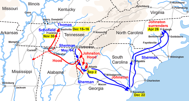
English: Map of the Western Theatre of the American Civil War, actions from Chattanooga to the Carolinas. Drawn by Hal Jespersen in Adobe Illustrator CS5. Graphic source file is available at http://www.posix.com/CWmaps/
|
| Date | 2006-10-06 (original upload date) |
| Source | Transferred from it.wikipedia; transfer was stated to be made by User:MaEr. |
| Author | Original uploader was Starlight at it.wikipedia |
Licensing
| This file is licensed under the Creative Commons Attribution 3.0 Unported license. | ||
| Attribution: Map by Hal Jespersen, www.posix.com/CW | ||
|
File usage
The following pages on Schools Wikipedia link to this image (list may be incomplete):
Metadata
Schools Wikipedia and SOS Children
All five editions of Schools Wikipedia were compiled by SOS Childrens Villages. SOS Childrens Villages works in 133 countries and territories across the globe, helps more than 62,000 children, and reaches over 2 million people in total. Learn more about child sponsorship.