
File:NOAA Katrina NOLA 17th Street breach Aug 31 2005.jpg
| |
This is a file from the Wikimedia Commons. Information from its description page there is shown below.
Commons is a freely licensed media file repository. You can help. |
Summary
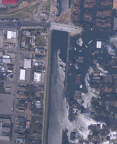
Breach in 17th Street Canal wall in New Orleans, Louisiana. A part of the West End neighbourhood of New Orleans is to the right on the east side of the canal, severely flooded; to the left, west of the Canal, is part of Metairie, Louisiana, not flooded. NOAA aerial image taken August 31, 2005.
Metal girders and/or plates were later hung along the north side of the Hammond Highway bridge (gray bridge at top, with debris in canal on the north/Lake Pontchartrain side) to block the entrance to the canal. The breach in the canal berm and canal wall (lower right) were closed with helicopter-dropped sandbags and trucks dumping fill southward from Hammond Highway.
The breach was closed Monday, September 5, 2005. An opening was then made in the metal wall to allow city drainage through the canal. Repair of the canal levee and floodwall are still ongoing as of April 2006.
Source
http://ngs.woc.noaa.gov/storms/katrina/24425575.jpg
Cropped and rotated 90 degrees so top is toward north.
- full photo uploaded as Image:17StreetCanalWestEndAfterKatrina.jpg
Licensing
 |
This image is in the public domain because it contains materials that originally came from the U.S. National Oceanic and Atmospheric Administration, taken or made as part of an employee's official duties.
|
 |
File usage
Want to know more?
SOS Children has brought Wikipedia to the classroom. SOS Children is an international children's charity, providing a good home and loving family to thousands of children who have lost their parents. We also work with communities to help vulnerable families stay together and raise children in the best possible environment. We have helped children in Africa for many years - you can help too...