 |
This is a file from the Wikimedia Commons. Information from its description page there is shown below.
Commons is a freely licensed media file repository. You can help.
|
Summary
| Description |
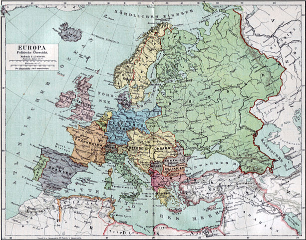
Politische Karte Europas ca. 1890 |
| Date |
1892 |
| Source |
Meyers Kleines Konversationslexikon. Fünfte, umgearbeitete und vermehrte Auflage. Bd. 1. Bibliographisches Institut, Leipzig und Wien 1892. |
| Author |
unbekannt, scan by sidonius 15:36, 7 November 2006 (UTC) |
Permission
( Reusing this file) |
| Public domainPublic domainfalsefalse |
 |
Diese Abbildung stammt aus der 5. Auflage von Meyers Konversationslexikon (1893-97). Das Urheberrecht ist erloschen, die Inhalte sind gemeinfrei.
|
 |
This image comes from the 5th edition of Meyers Konversationslexikon (1893-97). The copyrights have expired and this image is in the public domain.
|
|
| Maps of the history of Europe |
BC
aC |
Middle Neolithic · Late Neolithic · 220
|
|
AD
dC |
60 · 125 · 395 · 400 · 450 · 476 · 526 · 526-600 · 800 · 814 · 843-870 · 998 · 1000 · 1092 · 1097 · 1135 · 1142 · 1190 · 1328 · 1360 · 1400 · C.15 · 1430 · 1470 · 1490 · 1500 · 1519 · 1550 · 1560 · 1648 · 1700 · 1708 · 1740 · 1748 · 1787 · 1812 · 1815 · 1815 · 1890 · 1905 · 1911 · 1914 · 1919 · 1919-29 · 1923 · 1941-42 · 1942-45 · 1945-89 · 1993-2006 · 2006 to date
|
| (this template: · view · discuss ) |
File usage
The following pages on Schools Wikipedia link to this image (list may be incomplete):


