Checked content

File:MODIS Map.jpg

Summary

Description
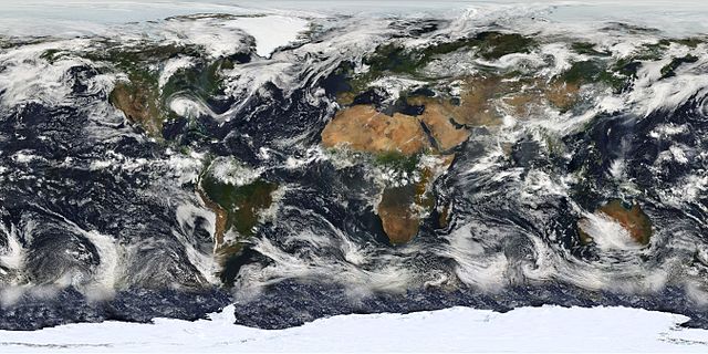
English: Image based largely on observations from the Moderate Resolution Imaging Spectroradiometer (MODIS) on July 11, 2005. Small gaps in MODIS’ coverage between overpasses, as well as Antarctica, have been filled in using GOES weather satellites and the latest version of the NASA Blue Marble.
Français : Planisphère montrant la terre telle qu'elle a été observée par le satellite MODIS le 11 juillet 2005. Les petits trous dans la couveture de MODIS ont été comblés avec des données provenant des satellites GOES, et la dernière version de la Blue marble ( bille bleue) de la NASA.
Italiano: Una foto satellitare della superficie terrestre, elaborata, in larga parte, dalle immagini fornite dalle fotocamere MODIS che equipaggiano i satelliti per telerilevamento Aqua ( EOS PM-1) e Terra (EOS AM-1).
Русский: Изображение, созданное главным образом по данным сканирующего спутникового спектрорадиометра MODIS (2005-07-11.) Небольшие «пропуски» между покрытиями прибора, а также Антарктика, были восстановлены с использованием данных метеоспутников GOES и последней версии « голубого мрамора» NASA.
Date 11 July 2005
Source Earth's Vital Signs
Author NASA
POTY
Cscr-featured.svg

Wikimedia CommonsWikipedia

This is a featured picture on Wikimedia Commons ( Featured pictures) and is considered one of the finest images.

Cscr-featured.svgSound-icon-empty.svgThis is a featured picture on the English language Wikipedia ( Featured pictures) and is considered one of the finest images.
Cscr-featured.svgSound-icon-empty.svgThis is a featured picture on the Turkish language Wikipedia ( Seçkin resimler) and is considered one of the finest images.

If you have an image of similar quality that can be published under a suitable copyright license, be sure to upload it, tag it, and nominate it.


Picture of the day

This image was selected as picture of the day on Wikimedia Commons for 21 May 2010. It was captioned as follows:

English: Image based largely on observations from MODIS.

Based on data from the MODIS science team.

Licensing

Public domain This file is in the public domain because it was solely created by NASA. NASA copyright policy states that "NASA material is not protected by copyright unless noted". (See Template:PD-USGov, NASA copyright policy page or JPL Image Use Policy.)
NASA logo.svg
Dialog-warning.svg
Warnings:
  • Use of NASA logos, insignia and emblems are restricted per US law 14 CFR 1221.
  • The NASA website hosts a large number of images from the Soviet/ Russian space agency, and other non-American space agencies. These are not necessarily in the public domain.
  • Materials based on Hubble Space Telescope data may be copyrighted if they are not explicitly produced by the STScI. See also {{ PD-Hubble}} and {{ Cc-Hubble}}.
  • The SOHO (ESA & NASA) joint project implies that all materials created by its probe are copyrighted and require permission for commercial non-educational use.
  • Images featured on the Astronomy Picture of the Day (APOD) web site may be copyrighted.
The following pages on Schools Wikipedia link to this image (list may be incomplete):

Did you know...?

Wikipedia for Schools is one of SOS Children's Villages' many educational projects. SOS Childrens Villages is there for the children in our care until they are ready for independence. Sponsoring a child is a great way to help children who need your support.