
File:IndoGangeticPlain Map.png
| |
This is a file from the Wikimedia Commons. Information from its description page there is shown below.
Commons is a freely licensed media file repository. You can help. |
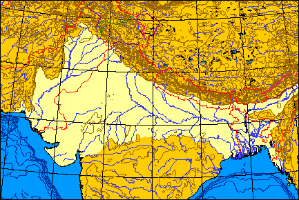
Map of the Indo-Gangetic Plain.
 |
I, the copyright holder of this work, release this work into the public domain. This applies worldwide. In some countries this may not be legally possible; if so: I grant anyone the right to use this work for any purpose, without any conditions, unless such conditions are required by law.
|
I produced this map myself using the program here and modifying it. It remains in the public domain. The map is an azimuthal equal-area projection. The Line of Control through Kashmir is green. Where the line of control along the Indo-Chinese frontier coincides with one side's territorial claims, the line is pink; borders claimed but not controlled are purple. Non-disputed boudaries are in red. QuartierLatin1968 01:36, 21 May 2005 (UTC)
File usage
The following pages on Schools Wikipedia link to this image (list may be incomplete):
Did you know...?
All five editions of Schools Wikipedia were compiled by SOS Children's Villages. SOS Childrens Villages is famous for the love and shelter it brings to lone children, but we also support families in the areas around our Children's Villages, helping those who need us the most. Go to http://www.soschildrensvillages.org.uk/sponsor-a-child to sponsor a child.