 |
This is a file from the Wikimedia Commons. Information from its description page there is shown below.
Commons is a freely licensed media file repository. You can help.
|
| Description |
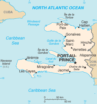
Map of Haiti |
| Date |
Newest revision from 2008 World Factbook |
| Source |
https://www.cia.gov/library/publications/the-world-factbook/geos/ha.html |
| Author |
CIA |
| Public domainPublic domainfalsefalse |
 |
This image is in the public domain because it contains materials that originally came from the United States Central Intelligence Agency's World Factbook.
|
|
| date/time |
username |
edit summary |
| 23:34, 20 November 2004 |
en:User:Neutrality |
|
| 23:34, 20 November 2004 |
en:User:Neutrality |
|
| 23:33, 20 November 2004 |
en:User:Neutrality |
(Map of Haiti. {{PD-USGov-CIA}}) |
Historio de la dosiero
Legend: (cur) = this is the current file, (del) = delete this old version, (rev) = revert to this old version.
Click on date to download the file or see the image uploaded on that date.
- (del) (cur) 23:33, 20 November 2004 . . en:User:Neutrality Neutrality ( en:User_talk:Neutrality Talk) . . 330x355 (14069 bytes) (Map of en:Haiti Haiti. { { PD-USGov-CIA } })
File usage
The following pages on Schools Wikipedia link to this image (list may be incomplete):


