
File:Sarasota Florida - 83d40m - from mainland across bay front to Gulf of Mexico - new bridge.JPG
| The uploader or another editor requests that the local copy of this file be kept. This image or media file may be available on the Wikimedia Commons as File:Sarasota Florida - 83d40m - from mainland across bay front to Gulf of Mexico - new bridge.JPG. While the license of this work may be compliant with the Wikimedia Commons, an editor has requested that the local copy be kept too. This file does not meet CSD F8, and should not be nominated for deletion as a Commons duplicate without the permission of the tagging editor. |
|
Summary
| Description |
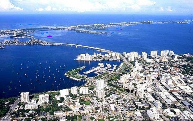
an aerial view of Sarasota, Florida seen from the mainland in the foreground showing her harbour and bay front from the Marie Selby Botanical Gardens at Mound Street to the Van Wezel Performing Arts Hall just south of Tenth Street. In the centre is the new bridge across Sarasota Bay; also showing (left to right, clockwise in the distance) part of Bird Key, Coon Key, Saint Armand Key, Lido Key, and part of Longboat Key; in the farthest distance is the Gulf of Mexico. In the foreground Orange Avenue runs left to right from the botanical gardens to the divide by the Herald Square Building at the Burns Square district where Pineapple Avenue and Orange Avenue create the triangle that is completed by (Charles) Ringling Boulevard, which crosses them both and leads to the bay front park entrance. Both Orange and Pineapple can be followed all the way to the right of the photograph. Main Street is difficult to distinguish because it rises from the harbor and makes a turn that is blocked by tall buildings, but part of it can be located by following the central dock in the harbour along a projection of its line to where lower Main Street intersects Tamiami Trail winding along the bay front drive. About a block farther to the right the trail turns north (where it intersects the causeway to the bridge) toward Indian Beach, Sapphire Shores, the John and Mable Ringling Museum of Art, and the Manatee County line (about five miles north) currently where the most northerly city boundary reaches as well. To the right of Ringling Boulevard in the extreme foreground, upper Main Street can be distinguished by counting two blocks to the right and along it, one can see many long, low, flat-roofed buildings on either side of the street for several blocks, that is the upper portion of Main Street between Orange and Pineapple where many stores and restaurants are located. Its path becomes vague at Five Points, where Pineapple crosses it, and Main Street begins its decent to the harbour. |
|---|---|
| Source |
this is an edited scan of my own photograph |
| Date |
June 29, 2008 |
| Author |
83d40m ( talk) 19:41, 29 June 2008 (UTC) |
| Permission ( Reusing this file) |
See below.
|
Licensing:
|
I, the copyright holder of this work, hereby publish it under the following license:
|
File usage
The following file is a duplicate of this file ( more details):
Metadata
Learn more
SOS Children chose the best bits of Wikipedia to help you learn. SOS Children helps those who have nothing and no one, giving them back the famly they have lost and bringing them the very best opportunities for a happy, healthy future. Want to learn more? Go to http://www.soschildrensvillages.org.uk/sponsor-a-child