
File:Frankfurt Am Main-Altstadt-Zerstoerung-Luftbild 1944.jpg
Size of this preview: 596 × 479 pixels.
| |
This is a file from the Wikimedia Commons. Information from its description page there is shown below.
Commons is a freely licensed media file repository. You can help. |
| Description |
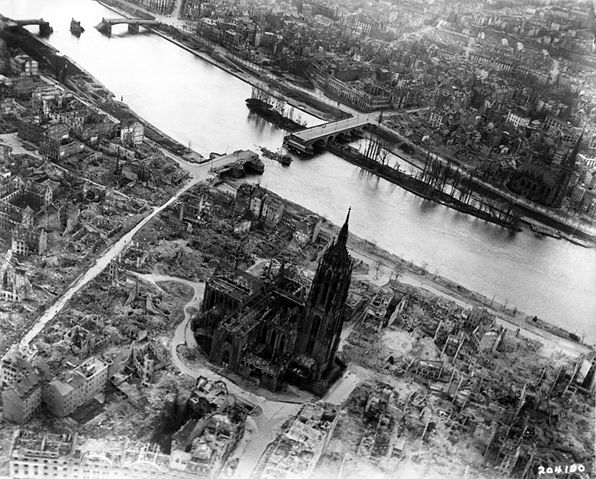
English: Frankfurt on the Main: Centre of the Altstadt (Old Town) with the Cathedral, western part of the Fischerfeldviertel (Fisher Field Quarter) and the major part of Sachsenhausen with heavy damage and devastations of the allied bombings of World War II as seen from the air from about the Braubachstrasse (Braubach Street) to the south
Deutsch: Frankfurt am Main: Zentrum der Altstadt mit dem Dom, westlicher Teil des Fischerfeldviertels und der größte Teil von Sachsenhausen mit erheblichen Zerstörungen und Schäden der allierten Bombardements des Zweiten Weltkrieges, ungefähr von Höhe der Braubachstraße aus der Luft nach Süden gesehen
Français : Francfort sur le Main: Centre de la Vieille Ville avec vue sur la cathédrale, la partie Ouest du quartier Fischerfeld et de la majeure partie de Sachsenhausen. Les lourds dégats et destructions suite aux bombardements alliés de la Seconde Guerre Mondiale sont visibles sur cette vue aérienne de la rue Braubach vers le Sud.
|
| Date | 31 March 1945 |
| Source | Private collection Mylius |
| Author | Unknown |
|
Camera location |
|
View this and other nearby images on: Google Maps - Google Earth - OpenStreetMap | ( Info) |
|---|
Licensing
 |
This image or file is a work of a U.S. Air Force Airman or employee, taken or made as part of that person's official duties. As a work of the U.S. federal government, the image or file is in the public domain.
|
 |
File usage
The following pages on Schools Wikipedia link to this image (list may be incomplete):
Metadata
I want to learn more...
SOS Childrens Villages aims to make Wikipedia suitable for young learners. SOS Childrens Villages helps more than 2 million people across 133 countries around the world. You can help by sponsoring a child.