Checked content

File:Race and ethnicity 2010- Houston.png
Summary

Description
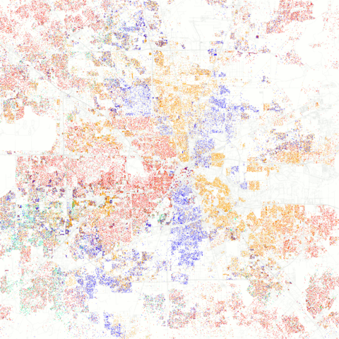
English: Maps of racial and ethnic divisions in US cities, inspired by Bill Rankin's map of Chicago, updated for Census 2010.

Red is White, Blue is Black, Green is Asian, Orange is Hispanic, Yellow is Other, and each dot is 25 residents.

Data from Census 2010. Base map © OpenStreetMap, CC-BY-SA
Date 25 March 2011, 21:55
Source Race and ethnicity 2010: Houston
Author Eric Fischer

Camera location

29° 45′ 46.42″ N, 95° 22′ 59.42″ W

This and other images at their locations on: Google Maps - Google Earth - OpenStreetMap ( Info)

Licensing

w:en:Creative Commons
attribution share alike
This file is licensed under the Creative Commons Attribution-Share Alike 2.0 Generic license.
You are free:
  • to share – to copy, distribute and transmit the work
  • to remix – to adapt the work
Under the following conditions:
  • attribution – You must attribute the work in the manner specified by the author or licensor (but not in any way that suggests that they endorse you or your use of the work).
  • share alike – If you alter, transform, or build upon this work, you may distribute the resulting work only under the same or similar license to this one.

Checked copyright icon.svg This image was originally posted to Flickr by Eric Fischer at http://flickr.com/photos/24431382@N03/5560487046. It was reviewed on 18 September 2011 by the FlickreviewR robot and was confirmed to be licensed under the terms of the cc-by-sa-2.0.
The following pages on Schools Wikipedia link to this image (list may be incomplete):

What is Schools Wikipedia?

All five editions of Schools Wikipedia were compiled by SOS Children's Villages. SOS Children believes that a decent childhood is essential to a happy, healthy. Our community work brings families new opportunities through education, healthcare and all manner of support. We have helped children in Africa for many years - you can help too...