Checked content

File:K-T boundary.jpg

Summary

Description
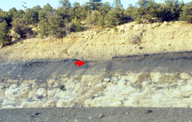
English: K-T boundary (red arrow) along Interstate 25, Raton Pass, Colorado
Deutsch: KT-Grenze (Roter Pfeil) entlang der Interstate 25, Raton Pass, Colorado
Date April 1992
Source Own work by Ank-man, first upload here
Author Anky-man at en.wikipedia

Licensing

Anky-man at the English language Wikipedia, the copyright holder of this work, hereby publishes it under the following license:
GNU head Permission is granted to copy, distribute and/or modify this document under the terms of the GNU Free Documentation License, Version 1.2 or any later version published by the Free Software Foundation; with no Invariant Sections, no Front-Cover Texts, and no Back-Cover Texts. A copy of the license is included in the section entitled GNU Free Documentation License.

w:en:Creative Commons
attribution share alike
This file is licensed under the Creative Commons Attribution-Share Alike 3.0 Unported license.
Attribution: Anky-man at the English language Wikipedia
You are free:
  • to share – to copy, distribute and transmit the work
  • to remix – to adapt the work
Under the following conditions:
  • attribution – You must attribute the work in the manner specified by the author or licensor (but not in any way that suggests that they endorse you or your use of the work).
  • share alike – If you alter, transform, or build upon this work, you may distribute the resulting work only under the same or similar license to this one.
This licensing tag was added to this file as part of the GFDL licensing update.

The following pages on Schools Wikipedia link to this image (list may be incomplete):

Did you know...?

SOS Childrens Villages aims to make Wikipedia suitable for young learners. SOS Children's Villages is a global charity founded in 1949 to give children who have lost everything the childhood they deserve. Have you heard about child sponsorship? Learn more...