Checked content

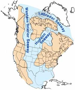
File:Cretaceous seaway.png

Cretaceous_seaway.png(250 × 301 pixels, file size: 101 KB, MIME type: image/png)

Map of North America highlighting the shallow inland seaways present during the mid- Cretaceous period. By William A. Cobban and Kevin C. McKinney, USGS. (Image has been slightly modified by uploader to remove "CO" state designation.)


Public domain This image is in the public domain because it contains materials that originally came from the United States Geological Survey, an agency of the United States Department of the Interior. For more information, see the official USGS copyright policy.

български | català | Deutsch | English | español | eesti | suomi | français | galego | italiano | 한국어 | македонски | മലയാളം | Nederlands | polski | português | русский | Türkçe | 中文 | 中文(简体)‎ | +/−

USGS logo green.svg
The following pages on Schools Wikipedia link to this image (list may be incomplete):

Learn more about Schools Wikipedia

All five editions of Schools Wikipedia were compiled by SOS Childrens Villages. SOS Children believes education is an important part of a child's life. That's why we ensure they receive nursery care as well as high-quality primary and secondary education. When they leave school, we support the children in our care as they progress to vocational training or higher education. Find out how you can help children in other countries.